Tropical Storm Barry, the second named tropical storm of the 2025 Atlantic hurricane season, made a short-lived but significant appearance before weakening over Mexico. It struck just south of its on Sunday evening and quickly lost strength as it pushed inland, eventually dissipating overnight. While Barry no longer poses a threat, forecasters are closely monitoring a new disturbance near Florida that could bring further tropical activity in the days ahead.
The pathway of Tropical Storm Barry
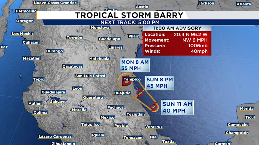
Barry’s Final Hours Over Mexico
Its Storm Barry Florida watchers saw the system intensify briefly over the weekend before weakening into a depression. The National Hurricane Center (NHC) confirmed Barry made landfall around 8 p.m. local time, with sustained winds of 35 mph. By early Monday, Barry had dissipated, its remnants moving northwest at around 12 mph.
Despite its short lifespan, Tropical Storm Barry brought heavy rain to parts of eastern Mexico. The states of San Luis Potosí and Tamaulipas experienced rainfall between 3 to 5 inches, with isolated areas receiving up to 8 inches. These downpours raised serious concerns about flooding and mudslides across the region.
The challenging terrain of eastern Mexico often leads to accelerated weakening of systems, but it also heightens the risk of flash flooding, especially in low-lying communities and mountainous areas. Emergency services remained on high alert through Monday to respond to any weather-related incidents.
Disturbance Brewing Near Florida
Even as Barry faded, attention quickly shifted to the Gulf of Mexico. A disturbance hovering near the southeastern United States has caught the eye of meteorologists. While the system has a low probability of developing into a storm, it remains worth watching—particularly for residents of Florida and nearby coastal areas.
The disturbance currently carries a 20% chance of formation within the next seven days. Forecast models suggest the system may weaken as it stalls off Florida’s coast later this week. However, some tropical or subtropical development remains possible if a low-pressure centre forms along the decaying frontal boundary over Florida or the eastern Gulf.
At this stage, forecasters do not expect the disturbance to affect Louisiana, but as with all tropical storms, situations can change rapidly. Authorities encourage people living along the Gulf Coast to monitor weather updates regularly.
2025 Hurricane Season Could Be Intense
The Atlantic hurricane season runs from June 1 to November 30 each year, and 2025 appears to be an active one. Barry was only the second named storm, yet experts already predict a busier-than-average season. Warm ocean temperatures, favourable atmospheric conditions, and early tropical storm activity support the forecast.
Historically, storms and hurricanes during early season months are not unusual. Many systems start small and remain disorganised before gaining strength later in the season. However, the appearance of multiple systems—like Barry and now Flossie in the Pacific—suggests heightened tropical activity.
Tropical Storm Flossie Gains Strength in the Pacific
Meanwhile, on the other side of Mexico,this Storm Flossie continues to churn off the southwestern Pacific coast. As of Monday morning, it held sustained winds of 45 mph and was moving northwest at 10 mph. The Mexican government has issued a tropical storm warning from Punta San Telmo to Playa Perula, and a watch remains in effect from Zihuatanejo to Cabo Corrientes.
Flossie is expected to strengthen into a hurricane by late Monday or Tuesday. Though its core is forecast to stay offshore, coastal regions in Oaxaca, Guerrero, Michoacán, Colima, and Jalisco can expect moderate rainfall through early next week.
Also Read: Trump’s Citizenship Order Faces New Legal Test After High Court Ruling
Also Read: Teen Survivor Pulled from Surf After Shark Attack at Cabarita Beach
A Reminder of Nature’s Unpredictability
Tropical Storm Barry may have dissipated quickly, but it served as a reminder of how tropical storms can evolve rapidly and leave behind serious consequences. The ongoing developments near Florida and in the Pacific reinforce the need for preparedness and resilience.
In a year likely to feature increased tropical activity, people in vulnerable regions should stay informed, follow official guidance, and have emergency plans in place. As forecasters keep their eyes on the tropics, communities must remain alert, ready to respond at a moment’s notice.