Tropical Cyclone Alfred 2025 continues to strengthen off the Queensland coast, raising concerns for coastal communities. The system, currently classified as a Category 2 cyclone, is expected to intensify into a Category 3 storm by Tuesday night or early Wednesday.
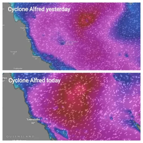
Figure 1: Cyclone Alfred’s intensity today (Below) compared to yesterday (above) [Colitco, Windy]
Meanwhile, Tropical Cyclone Bianca is moving away from Western Australia, posing no direct threat, while Cyclone Rae, which struck Fiji as a Category 2 system, is now leaving the region.
A spokesperson from BOM mentioned, “Tropical Cyclone Bianca, sitting off the Western Australia coast, is expected to continue moving away from Australia and bring no direct impacts to the Australian region.”
Watch Here:
National Weather Forecast: Settled for many areas, showers and storms for parts of the east coast.
Video current as of 2:00pm AEDT 24 February 2025.
Details: https://t.co/4W35o8iFmh or the BOM Weather app. pic.twitter.com/IcVJVSqaEC
— Bureau of Meteorology, Australia (@BOM_au) February 24, 2025
The Bureau of Meteorology (BOM) is closely monitoring Tropical Cyclone Alfred, warning that its movement later in the week remains uncertain.
Also Read: Tropical Cyclone Alfred Strengthens Off Queensland Coast, Uncertain Path Ahead
Tropical Cyclone Alfred Forecast
- Current Location: 950 km east-northeast of Mackay
- Category: 2 (Expected to intensify to Category 3)
- Movement: Tracking south-southeast toward the Queensland coast
- Potential Impacts: Gusty winds, large waves, and increased rainfall in coastal areas
Although Alfred is still offshore, meteorologists stress that changes in its track could alter its potential impacts. Some forecasts suggest it may move closer to the Queensland coast, while others predict it could remain further offshore.
A weather spokesperson from BOM stated, “[Cyclone Alfred is] a very windy system and pretty large system well off the Queensland coast.”
Watch the Update:
Severe Weather Update: Tropical Cyclone Alfred update.
Video current: 12:30pm AEST 25 February 2025.
Latest forecasts and warnings: https://t.co/4W35o8iFmh or the BOM Weather app. pic.twitter.com/USNqpyX693
— Bureau of Meteorology, Australia (@BOM_au) February 25, 2025
Queensland Braces for Strong Winds and Rough Seas
Queensland’s coastal communities are already feeling the effects of Cyclone Alfred. Winds are strengthening, and large waves are forming between Townsville and K’gari.
Residents in affected regions should remain vigilant for warnings and updates from the Bureau of Meteorology.
Expected Impacts in Queensland:
✔️ Strong winds along the coast
✔️ Rough seas and large waves
✔️ Showers and possible thunderstorms
✔️ Hot and humid conditions inland
Despite the approaching cyclone, Brisbane will remain relatively settled, with partly cloudy skies and a maximum temperature of 31°C.
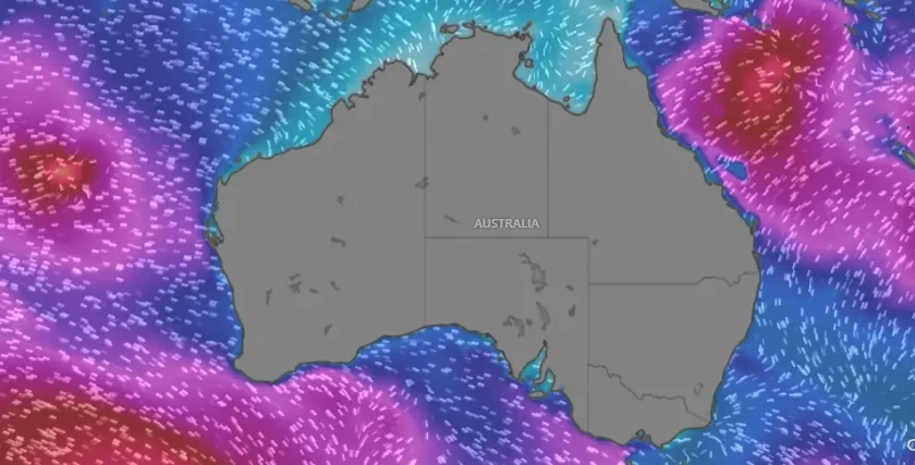
Figure 1: Cyclone Alfred and Bianca around Australia [Windy.com]
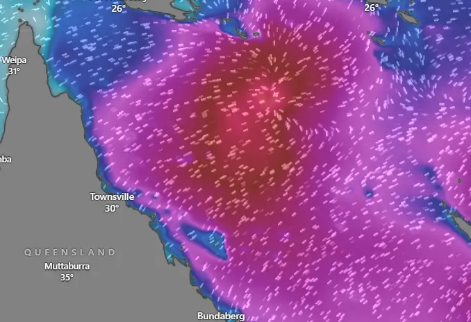
Figure 2: Cyclone Alfred near Queensland [Windy.com]
National Weather Forecast for Tuesday, 25th February
Beyond Queensland, weather conditions across Australia will vary significantly.
New South Wales
- Showers and thunderstorms expected in the ranges and slopes.
- Some storms may bring locally heavy rain and gusty winds.
- Sydney: A shower or two, with a maximum of 25°C.
- Canberra: Dry and warm, reaching 27°C.
Victoria
- Generally settled conditions, with morning fog in Gippsland.
- Melbourne: A sunny day, with a maximum of 27°C.
Tasmania
- Light, patchy showers possible in the west.
- Hobart: Mostly clear skies, with a high of 24°C.
South Australia
- Hot and dry conditions dominate the state.
- Low-intensity heatwave conditions in the far north.
- Adelaide: Sunny and warm, with a top of 33°C.
Western Australia
- Cyclone Bianca moves further offshore.
- Showers and thunderstorms expected in parts of the state.
- Perth: Partly cloudy, with a top of 28°C.
Northern Territory
- Monsoon break continues, but isolated showers and storms remain possible.
- Some gusty winds may develop along the East Kimberley coast.
- Darwin: Showers, a possible thunderstorm, and a maximum of 33°C.
Tracking Cyclone Alfred’s Movement
As Cyclone Alfred intensifies, its future path remains uncertain. Weather models show different scenarios:
1️⃣ Alfred could track closer to Queensland’s coast, bringing stronger winds and rough seas.
2️⃣ It could continue further south and offshore, reducing its direct impact.
The Bureau of Meteorology will release track maps every six hours to provide the latest updates.
Meteorologists stress the importance of monitoring the cyclone’s movement as changes in its path could affect warnings for coastal communities.
Cyclone Safety and Preparedness
Authorities urge residents in potentially affected regions to stay updated via:
📌 Bureau of Meteorology’s website and BOM Weather app
📌 Local emergency services alerts
📌 Official social media updates
While Cyclone Alfred is not expected to cause widespread damage, coastal communities should remain cautious. Strong winds, rough seas, and heavy showers could still impact daily activities.
Stay Informed on Tropical Cyclone Alfred 2025
As Tropical Cyclone Alfred 2025 develops, Australians are advised to:
✅ Follow official weather warnings
✅ Prepare for rough seas and strong winds
✅ Stay informed on the cyclone’s latest movements
The Bureau of Meteorology will continue monitoring the system and providing regular updates. Stay tuned for further developments as Cyclone Alfred moves through the Coral Sea.