A powerful storm system is bringing severe weather to parts of the South and East. The system is producing tornadoes, damaging winds, and large hail. A Tornado Watch is in effect for North Texas, southeast Oklahoma, and southwest Arkansas until 11 a.m. CST Tuesday.
- The Dallas-Fort Worth Metroplex is included in the watch
- A few tornadoes and damaging wind gusts are possible
- Storms have already produced wind gusts of 74 mph at DFW International Airport and 72 mph in Waco
Storms Move Eastward with Enhanced Risk
The NOAA Storm Prediction Center has warned of severe thunderstorms affecting regions from eastern Texas and Oklahoma to the lower Mississippi Valley, Alabama, and western Georgia. Cities in the impact zone include:
- Jackson, Mississippi
- Little Rock, Arkansas
- New Orleans, Louisiana
- Shreveport, Louisiana
The primary threats include damaging winds and tornadoes. The greatest risk for EF2 or stronger tornadoes is in southern Arkansas, northern Louisiana, central and southern Mississippi, southwest Alabama, and the far western Florida Panhandle.
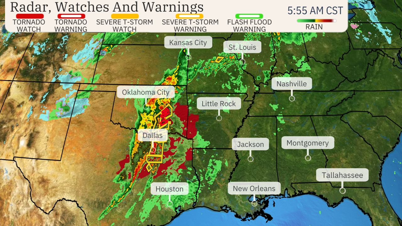
Figure 1: Current Radar, Watches And Warnings issued by NOAA
Severe Thunderstorm Warnings in Effect
Severe thunderstorms are rapidly moving through North Texas. The National Weather Service in Fort Worth has issued multiple warnings, with wind gusts reaching hurricane-force levels.
- At 5:30 a.m., DFW Airport recorded a 74 mph wind gust
- At 5:45 a.m., Love Field reported a 78 mph wind gust
- Winds of 60-70 mph are expected across Dallas, Collin, Denton, and Tarrant counties
- Affected highways include sections of Interstate 35E, I-20, I-30, and I-45
Over 101,700 customers were without power as of 5:36 a.m.
Also Read: Carl Dean, Husband of Dolly Parton, Dies at 82
Wind Advisory in Place for North Texas
A Wind Advisory remains active until 9 p.m. Tuesday. Expected conditions include:
- Sustained winds of 20 to 30 mph
- Wind gusts reaching 50 mph
- Travel difficulties, especially for high-profile vehicles
- Small tree limbs may break, causing damage
Authorities advise securing outdoor objects and preparing for power outages.
Fire Danger Elevated After Storms
Dry air and strong winds behind the cold front are increasing fire risk in parts of North Texas.
- A Fire Weather Watch is in place for areas along and south of I-20
- Humidity levels will drop to 15-20% Tuesday afternoon
- Winds behind the front will gust up to 45 mph
Residents are urged to avoid activities that could spark fires, including dragging chains, parking on dry grass, and discarding cigarette butts.
Weather Sirens Activated in Some Areas
FOX 4 Meteorologist Evan Andrews confirmed that weather sirens sound when winds exceed 70 mph. Multiple locations have reported gusts reaching this threshold.
Severe Weather Extends into Wednesday
The severe storm system will continue moving east, affecting parts of the East Coast on Wednesday. Cities at risk include:
- Charleston, South Carolina
- Raleigh, North Carolina
- Richmond, Virginia
- Washington, D.C.
Potential hazards include damaging winds, tornadoes, and localised flash flooding.
Severe Outbreak Forecast
Tuesday – Tuesday Night
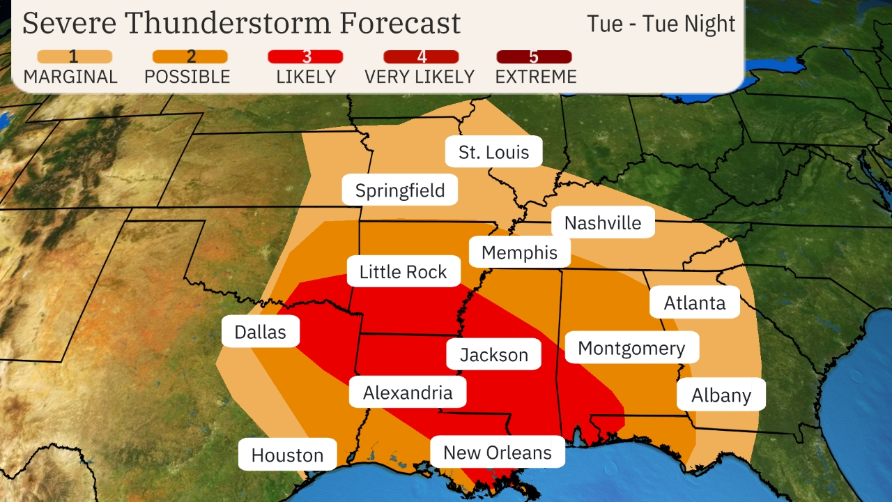
Figure 2: Tuesday-Tuesday Night Severe Thunderstorm Forecast
- Severe storms will continue across eastern Texas, eastern Oklahoma, the lower Mississippi Valley, Alabama, and western Georgia.
- A squall line will move across the region, producing damaging winds and tornadoes.
- Supercell thunderstorms could form ahead of the squall line, increasing tornado risk.
- The highest threat of strong EF2 or greater tornadoes is in southern Arkansas, northern Louisiana, central and southern Mississippi, and southwest Alabama.
- Heavy rainfall is expected, though flash flooding will be localised.
Wednesday
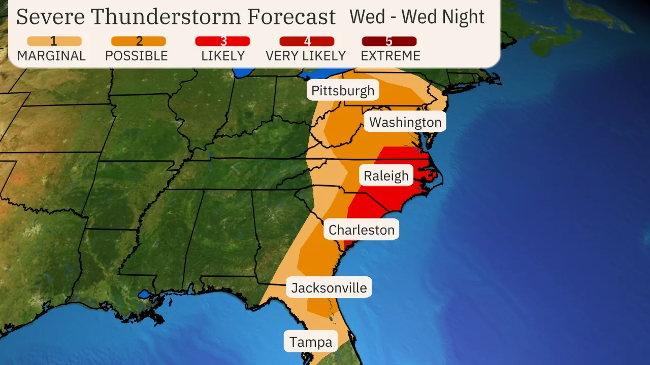
Figure 3: Wednesday-Wednesday Night Severe Thunderstorm Forecast
- The storm system will continue moving eastward, affecting areas from Delaware and Maryland to northern Florida.
- Cities at risk include Charleston, Raleigh, Richmond, and Washington, D.C.
- Damaging winds and isolated tornadoes remain possible.
- Flash flooding and strong non-thunderstorm wind gusts could impact the Northeast late Wednesday and into the night.
Public Advised to Stay Alert
Authorities urge residents to stay informed and prepared for severe weather conditions. Multiple sources for updates should be used, including weather apps, news stations, and official emergency alerts.