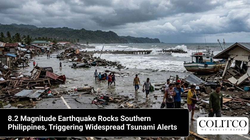
An 8.2 magnitude earthquake struck the southern region of the Philippines on Monday. The German Research Centre for Geosciences initially registered the event as a 7.3 magnitude tremor before upgrading the final calculation. This displacement of the earth triggered tsunami alerts across multiple sectors of the Pacific Ocean.
The United States Tsunami Warning System issued a threat notice to communities near the ocean. The Pacific Tsunami Warning Centre announced that waves could reach coastlines within three hours of the shock. This warning encompasses regions in Indonesia, Palau, Taiwan, Papua New Guinea and the Philippines.
The Philippines Seismology Agency advised residents along the coast to move inland or seek ground at higher elevations. The agency projects wave heights of more than one metre above the normal tide lines. Local authorities initiated evacuation protocols for citizens in southern provinces.
The United States Geological Survey reported a magnitude of 7.8 for the same geological event. Concurrently, Malaysia’s Meteorological Department registered a magnitude of 7.9. These variations happen because different networks collect data from separate telemetry stations around the globe.
Monitors noted no reports of casualties during the hour following the rupture. Response teams began inspections of infrastructure, buildings and transport links in the Mindanao region. Initial data indicate that the shaking did not collapse structures in the urban centres.
Why This Matters For Everyone
This event affects maritime transport, global trade routes and populations living near the ocean across the Pacific. Tsunamis travel at speeds of hundreds of kilometres per hour in depths of the ocean and threaten ports far from the epicentre. People in these zones must monitor the situation to protect lives and property.
The rupture also creates risks for energy supplies and communication networks throughout Southeast Asia. Previous events in this region severed fibre-optic cables on the ocean floor and slowed internet traffic for days. Disruptions in the Philippines impact global supply chains for electronics components and agriculture.
Residents in neighbouring nations like Malaysia felt the earth move during the breakfast hour. This connection shows how tectonic activity ignores political borders and influences regional safety strategies. Readers track these developments to evaluate the efficacy of warning systems during crises.
Insurance markets and disaster relief agencies monitor these measurements to calculate financial exposure. A magnitude above 8.0 alters risk models for infrastructure investment in the western Pacific. Governments use this data to adjust building codes and funding for emergency services.
Who’s Responding And Involved
The bodies tracking the situation include the German Research Centre for Geosciences and the United States Geological Survey. Specialists at these centres read data from sensors and issue statements to the public. The Pacific Tsunami Warning Centre manages the dissemination of wave alerts to international governments.
Inside the Philippines, the Philippines Seismology Agency directs the local emergency operations. Administrators in provinces like Davao Oriental, Surigao del Sur and Leyte coordinate the movement of citizens. Police personnel and rescue squads assist families as they move away from the beaches.
Malaysia’s Meteorological Department monitors the conditions in the state of Sabah to ensure safety. Scientists in Japan, Taiwan and New Zealand also analyse sea level gauges for signs of water displacement. The Department of Education in the zone assesses school buildings for structural safety.
Telecommunications companies like Globe Telecom check network towers for operational status. The National Grid Corporation of the Philippines inspects transmission lines and power plants that went offline. Engineering teams lead the work to restore electricity to communities in Mindanao.
Where The Quake Struck
The earthquake occurred off the coast of Mindanao, an island in the southern territory of the Philippines. The epicentre sat at coordinates 5.7 degrees North and 125.1 degrees East. This location lies 97 kilometres south of Koronadal City.
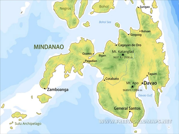
Figure 1: Mindanao Region Map. [Source: Free World Maps]
The map above shows the proximity of urban hubs to the southern coastline where the energy released. Viewers can locate Davao and General Santos, which sit within the zone of intense vibration. These locations experience higher risk due to their positions along the gulfs.
The vibrations travelled across the Celebes Sea into the East Malaysia region. People in the towns of Tawau and Semporna felt the tremors inside office buildings and homes. The warning system flags danger zones stretching along the western rim of the Pacific Ocean.
The fracture occurred along the Philippine Trench, a depression in the sea floor. This feature forms the boundary where the Philippine Sea Plate subducts under the Sunda Plate. The entire area sits within the Ring of Fire, a loop that contains most of the world’s volcanoes.
This tectonic overview illustrates the intersection of the Philippine Plate and the Eurasian Plate. Readers can track the pink band which marks the zones of high pressure and frequent rupture. This network of plate boundaries explains the frequency of events in the archipelago.
The affected provinces include Davao Oriental, Dinagat Islands, Surigao del Norte and Southern Leyte. These areas contain numerous fishing villages and ports that face the ocean directly. The geography of these bays can amplify the height of waves that approach.
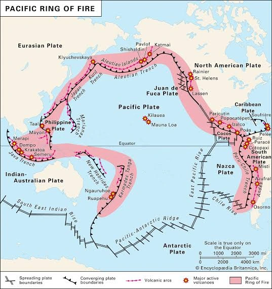
Figure 2: The Pacific Ring of Fire Boundaries [Source: Britannica]
When The Shaking Began
The earthquake occurred at 7:37 AM local time on Monday, June 8, 2026. Global monitoring networks recorded the signals within seconds of the rock fracture. Tsunami alert centres delivered the first notifications to governments four minutes later.
The Pacific Tsunami Warning Centre established a three-hour window for the arrival of waves. This timeline required emergency teams to clear zones near sea level before mid-morning. The evacuation orders remained active as scientists tracked water movements.
This event follows a sequence of earthquakes that hit the same provinces in late 2025. A doublet earthquake in October 2025 caused ten deaths and ruined thousands of homes. The event on June 8, 2026, occurred as communities finished rebuilding infrastructure from that prior disaster.
Also Read: SpaceX IPO Stock Price Draws Massive Investor Demand As Offering Becomes Oversubscribed
Historical records show that earthquakes hit this fault line every few decades. A doublet occurred in 1992, and another event shook Mindanao in December 2023. This timeline indicates that the trench has entered a phase of stress release.
What’s Next And How It Unfolded
The earthquake happened because tectonic plates slipped past each other at a depth of 10 kilometres. This movement displaced a section of the ocean floor and pushed the water column upward. The resulting wave propagates outward in all directions across the sea.
Quick facts: Seismic and Tsunami data
- The German Research Centre for Geosciences recorded a magnitude of 8.2 for the tremor.
- The focus of the earthquake sat at a depth of 10 kilometres below the sea bed.
- The location of the epicentre sat 97 kilometres south of Koronadal City.
- Modeling agencies project waves exceeding one metre above normal tide levels.
The event will play out as tide gauges transmit data electronically to the warning centres. If the water levels remain constant, authorities will lift the evacuation orders. If the gauges detect rises, sirens will signal the approach of waves to the coast.
Seismologists expect hundreds of aftershocks to rock the region during the next month. Later tremors can damage structures that the first shock weakened. Teams of engineers will inspect public utilities before citizens return to their homes.
International agencies will deliver aid and technical support if the tsunami causes damage. The United States and Japan previously provided assistance to the Philippines during emergencies in the past. The data from this event will help scientists refine models for wave predictions.
Sources
- https://news.sky.com/story/tsunami-alert-after-8-2-magnitude-quake-hits-the-philippines-13551811
- https://www.bbc.com/news/live/c20y4xp43ywt
Disclaimer
This article contains information compiled from preliminary reports issued by international seismological agencies on June 8, 2026. Scientific bodies frequently revise measurements and wave projections as new telemetry data becomes accessible. Readers should monitor local emergency broadcasts for immediate safety guidance and official mandates.

Luke Carlino is a seasoned Copywriter, Content Strategist, and Social Media Manager specialising in Mining, Finance, and Business journalism. With more than a decade of industry experience, he brings rigorous editorial standards and commercial acuity to every project.