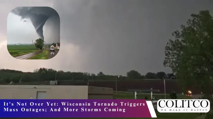
A powerful round of severe storms tore through Wisconsin overnight, triggering a Wisconsin weather tornado warning across multiple counties, knocking out power to tens of thousands of residents, and leaving a trail of structural damage from south-central Wisconsin all the way to the Milwaukee metro area.
However, this situation may not be the end right now. Forecasters warn that another round of dangerous storms will redevelop Tuesday afternoon and evening, meaning the worst may not be over yet.
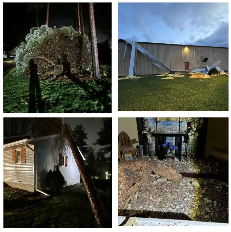
Figure 1: Multiple images showing devastation from the extreme weather events on April 13. [Source: Channel 3000]
What Happened Overnight
Storms Sweep Across Southern and South-east Wisconsin
Severe thunderstorms rolled through Wisconsin beginning Monday afternoon and continued into the early morning hours of Tuesday, April 14. The storms hit south-central Wisconsin first, then pushed east into the greater Milwaukee region.
FOX6 Weather Experts confirmed that all of Wisconsin faced a severe weather threat Monday afternoon and evening, with the overnight hours bringing the most destructive impacts, including downed trees, snapped power lines, and significant structural damage to buildings.
The National Weather Service issued a Wisconsin weather tornado warning for several counties during the event, and residents across the state scrambled to shelter as the storms intensified after dark.
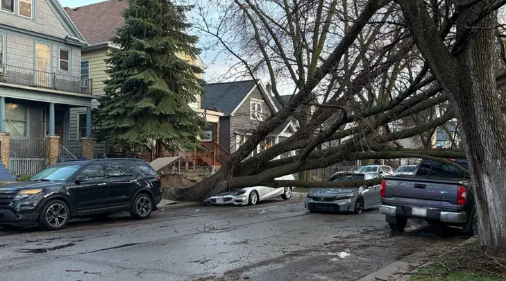
Figure 2: An image captures a massive tree that has toppled over onto a car at the intersection of 20th Street and Greenfield Avenue in Milwaukee. [Credit: Fox6]
Widespread Structural Damage Reported
The damage reports came in fast. Here’s a snapshot of what communities reported:
- East Bristol (Dane County): Severe storms caused major damage to St. Joseph Catholic Church, according to the church’s own Facebook page. Photos showed significant destruction to the structure.
- Prairie du Sac (Sauk County): Viewer-submitted photos captured fallen trees on homes and debris scattered through residential neighborhoods.
- Sauk County (Milwaukee Valve facility): Sauk County Dispatch confirmed roof damage at the Milwaukee Valve industrial site.
- Milwaukee (20th & Greenfield / 27th & Euclid): FOX6 received multiple reports of downed power lines and fallen trees across city neighborhoods.
Power Outages: By the Numbers
More Than 60,000 Customers in the Dark
The power outage numbers tell the full scale of the storm’s reach.
According to We Energies, more than 51,000 customers in southeast Wisconsin lost power by Tuesday morning. The Milwaukee Journal Sentinel reported the total number of utility customers statewide without power surpassed 60,000 as of April 14.
In south-central Wisconsin, the outages hit just as hard:
- Alliant Energy reported approximately 17,335 customers without power as of 4 a.m. Tuesday.
- Madison Gas and Electric reported an additional 5,164 customers offline at the same time.
The ripple effects hit schools almost immediately. Pewaukee Schools announced a two-hour delay Tuesday morning due to a campus-wide power outage. Whitewater Unified School District also pushed back its start time after power lines went down near several of its buildings.
We Energies encouraged any customer experiencing an outage to report it online, through the We Energies app, or by calling 1-800-662-4797.
More Storms on the Way
Tuesday Afternoon and Evening Bring Another Threat
If you thought the overnight storms marked the end of Wisconsin’s severe weather stretch, think again. Forecasters say the region faces another significant severe weather threat before the day is out.
The FOX6 Weather Experts say storms will redevelop Tuesday afternoon and evening, with the primary threats being:
- Damaging winds
- Isolated tornadoes
- Locally heavy rainfall
Channel 3000’s meteorologists declared Tuesday an Alert Day, noting that severe storm chances continue through Wednesday. The National Weather Service Storm Prediction Center also flagged southern Wisconsin for an elevated severe weather risk through midweek.
Residents in the Madison weather zone, including Dane County and surrounding areas, should stay weather-aware throughout Tuesday. Any tornado warning Milwaukee residents or south-central Wisconsin communities receive should prompt immediate shelter-in-place action.
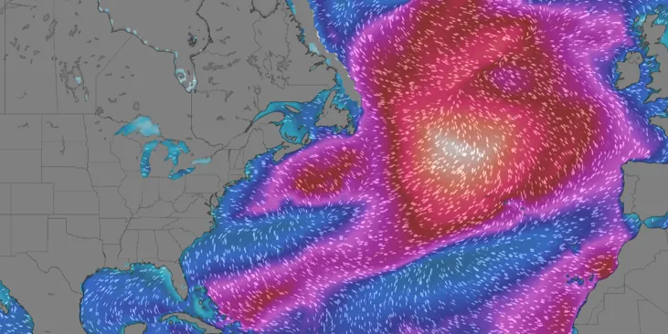
Figure 3: A weather map of the North Atlantic shows a large, intense swirling system, likely a powerful storm, east of the U.S. coast, with color gradients highlighting strong wind speeds and circulation patterns across the ocean. [Credit: Windy]
Extreme weather events like these have become a more familiar pattern across the U.S. Midwest in recent years. You can read more about how dangerous weather systems are affecting communities nationwide, including extreme heat watches across the United States.
Safety Tips: What to Do Right Now
Power Outage Safety
We Energies shared these key safety reminders for anyone currently without power or near downed lines:
- Stay at least 25 feet away from any downed power line; always treat them as energized.
- Use flashlights, not candles, to reduce fire risk.
- Keep refrigerator and freezer doors closed as much as possible to preserve food.
- Check on neighbors, especially the elderly and anyone with medical equipment that requires electricity.
Tornado Warning Protocol
If a Wisconsin weather tornado warning activates for your county, do not wait for the storm to arrive. Move immediately to the lowest interior room of a sturdy building — a basement if you have one. Stay away from windows and exterior walls.
Do not shelter in a vehicle or mobile home. If you are outdoors with no shelter available, lie flat in a low-lying area and protect your head.
What to Watch Tuesday
The Wisconsin weather tornado warning threat does not end with the morning. Here is what residents across the state need to monitor as the day continues:
- Watch for updated tornado warnings from the National Weather Service throughout the afternoon and evening hours.
- Keep an eye on Madison weather alerts through local channels and the NWS Madison office.
- Milwaukee-area residents should monitor any tornado warning notifications through emergency alert systems and local news.
- Power restoration timelines from We Energies, Alliant Energy, and Madison Gas and Electric remain fluid, check each utility’s outage map for the latest updates.
This remains a developing story. Conditions change fast during active severe weather pattern stretches like this one. Stay connected to local forecasters, sign up for emergency alerts from your county, and make sure your family has a storm plan ready to go.
Frequently Asked Questions (FAQs)
Q1: How many people lost power during the Wisconsin tornado warning?
Ans: Over 60,000 utility customers across Wisconsin lost power overnight, including 51,000+ through We Energies in southeast Wisconsin, 17,335 through Alliant Energy, and 5,164 through Madison Gas and Electric in the south-central region.
Q2: What areas did the Wisconsin tornado warning affect most?
Ans: The storm hit southern and southeast Wisconsin hardest — including Milwaukee, Madison, Dane County, Sauk County, Prairie du Sac, and East Bristol. Structural damage, downed trees, and snapped power lines were reported across all these areas.
Q3: Is another tornado warning expected in Wisconsin?
Ans: Yes. Forecasters say severe storms will redevelop Tuesday afternoon and evening, with threats of isolated tornadoes, damaging winds, and heavy rainfall. The National Weather Service has flagged southern Wisconsin for an elevated risk through midweek.
Q4: What should Wisconsin residents do during a tornado warning?
Ans: Move immediately to the lowest interior room of a sturdy building — a basement if possible. Stay away from windows, exterior walls, vehicles, and mobile homes. Keep emergency alerts active on your phone and monitor local weather updates throughout the day.
Sources
- https://www.fox6now.com/news/thousands-without-power-tuesday-after-storms-hit-southeast-wisconsin
- https://www.jsonline.com/story/news/local/2026/04/14/more-than-60000-wisconsin-utility-customers-without-power-april-14/89602840007/
- https://www.channel3000.com/news/overnight-storms-cause-widespread-damage-power-outages-across-south-central-wisconsin/article_9a9571be-157c-4a57-890f-503663c30ede.html
- https://watchers.news/2026/04/14/tornado-kansas-minnesota-iowa-wisconsin-severe-weather-outbreak-april-13-2026/