Cyclone 25U Strengthens Near Cocos Islands
A tropical low over the Indian Ocean is strengthening into a cyclone near the Cocos (Keeling) Islands. The Bureau of Meteorology (BoM) confirmed that Tropical Low 25U would develop into a cyclone as it tracks south. The cyclone will not impact the Australian mainland but will bring strong winds and squally showers to the Cocos Islands.
Meteorologist Miriam Bradbury said the system would gradually move further south and weaken by late Thursday.

Figure 1: Cyclone 25U Strengthens near West Island [Windy]
Second Tropical Low Forms Off Western Australia
A second tropical low, identified as 27U, is forming off the north-west Kimberley coast in Western Australia. The BoM stated that this system has a low chance of developing into a cyclone from Friday into the weekend.
Although it is expected to remain offshore, the system will bring increased rainfall to the Pilbara region. The bureau urged residents to monitor weather warnings over the coming days.
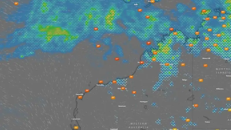
Figure 2: Two tropical lows developing off the north-west Australian coast [Windy]
Heavy Rain Batters North Queensland
Far North Queensland is experiencing torrential rainfall, with Townsville, Ingham, and Ayr receiving significant downpours. The BoM warned of potential flash flooding in these areas, with six-hourly rainfall totals reaching 120mm to 160mm. Isolated totals of 240mm were recorded.
Townsville recorded 301.4mm of rain in 24 hours, the highest daily total in 27 years. Between 1am and 9am, the city received 241.4mm, causing widespread flooding. Magnetic Island’s Horseshoe Bay recorded 351mm in the same period.
Severe Weather Update: Heavy rainfall has eased for north-east Queensland; flooding continues.
Video current: 12:30pm AEST 19 March 2025.
Latest forecasts and warnings: https://t.co/4W35o8iFmh or the BOM Weather app. pic.twitter.com/mtHAc9It43
— Bureau of Meteorology, Australia (@BOM_au) March 19, 2025
Record Rainfall Causes Flooding
Earlier in the year, Townsville experienced 710mm of rain in 72 hours, a rare one-in-2000-year event. This week’s downpour, while severe, is not expected to match February’s totals.
A slow-moving coastal trough and moisture-laden winds caused the intense rain. A mesoscale low, which formed southeast of Townsville, contributed to the heavy downpours.
Flood Warnings Issued for Queensland Rivers
The BoM issued flood warnings for several rivers in Queensland. The Herbert River at Halifax dropped below the minor flood level of 4.00 metres. However, minor to moderate flooding remains possible for the Haughton River and Upper Burdekin Catchment.
The following catchments are likely to experience flooding:
- Haughton River
- Cape River to Burdekin Falls Dam
- Murray River
- Black River
- Ross and Bohle Rivers
Flash Flooding and Road Closures in Townsville
Roads across Townsville remain closed, with cars submerged in floodwaters. There were nine State Emergency Service (SES) call-outs for water inundation and sandbagging.
Swiftwater rescue crews assisted a vehicle caught in floodwaters at Helens Hill near the Bruce Highway. Emergency services rescued a woman in her 90s, while another woman in her 70s escaped on her own.
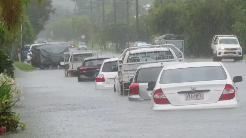
Figure 3: Cars in Townsville’s West End have been flooded overnight
Two minor rockfalls occurred in Belgian Gardens and Castle Hill.
Bruce Highway Reopened After Flood Closure
The Bruce Highway, which was cut off north of Ingham, reopened at 2pm after floodwaters receded. Supermarkets in Far North Queensland had only just recovered from supply shortages caused by Tropical Cyclone Alfred.
A Woolworths spokesperson stated that the company was closely monitoring the situation in Ingham.
Ingham Braces for Further Rainfall
Ingham, which suffered severe flooding in February, remains on alert. In February, 180 properties were severely affected by floods. Ingham Mayor Ramon Jayo expressed confidence that current forecasts would not cause similar devastation.
“There is no [expectation], based on the current forecast, for any houses or properties to be inundated at all,” Jayo said.
Weather conditions are expected to improve as the trough system weakens by late Wednesday.
Also Read: Trump Declassifies Final JFK Assassination Files, Reviving Decades-Old Controversy
Tropical Cyclone Risk Increases Due to Monsoon Activity
Meteorologists are closely watching two developing systems near Australia. The Madden-Julian Oscillation (MJO) is intensifying monsoonal winds, increasing the risk of cyclone activity.
The BoM forecasts that a tropical low will form off the Western Australian coast by Thursday. By Friday afternoon, there is a 15% chance it could develop into a cyclone.
Perth to Experience Hot and Dry Conditions
While northern Australia faces heavy rain, Perth will see sunshine and high temperatures. The city will have four consecutive days of 30°C or above, with Saturday reaching 35°C.

Figure 4: Today’s temperature forecast
Authorities Urge Residents to Stay Vigilant
Emergency services are urging residents across northern Australia to remain alert for further weather warnings. Communities in affected regions should monitor flood alerts and cyclone advisories over the coming days.