
Sydneysiders must prepare for a wet and gloomy week as rain grips New South Wales, with the Bureau of Meteorology forecasting showers from Monday through Sunday and rainfall remaining steady, with totals of 10 to 30mm expected each day, while the Illawarra region and eastern coastal areas brace for continuous wet weather until the weekend as meteorologist Miriam Bradbury confirmed consistent rainfall with “very low numbers through Wednesday.”
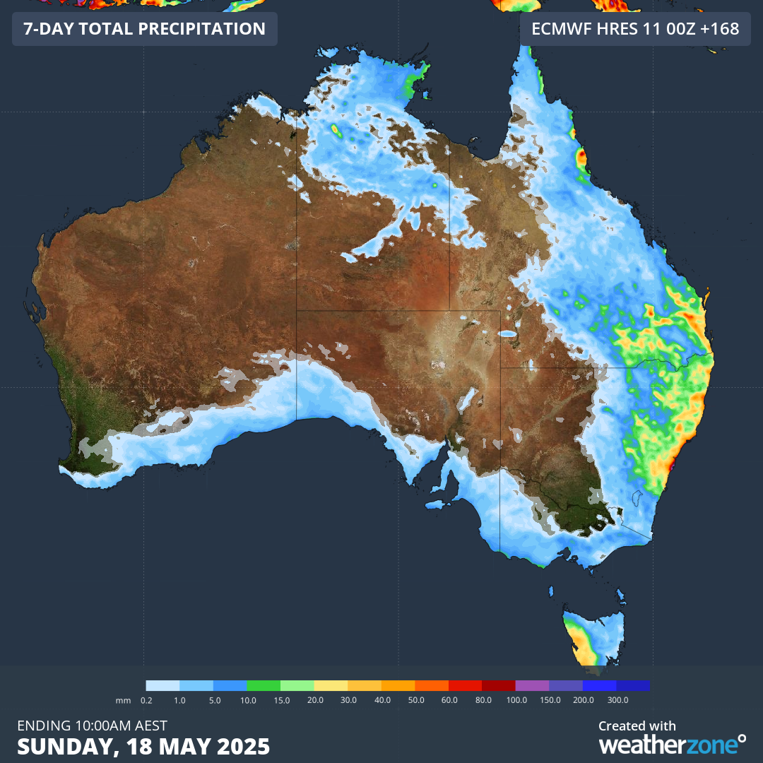
Figure 1: Weekly rainfall accumulation across Australia till Sunday, 18th May
Eastern Seaboard Bears the Brunt
Rain will remain concentrated over the NSW coast, stretching from the far north to the south, while patchy rain extends to northern NSW with periods of dry weather likely later in the week, and Sydney will experience persistent showers, leading to a soggy seven-day forecast as rainfall could total between 30mm to 70mm along the eastern fringe, with some localised areas possibly recording falls above 100mm.
Coastal Troughs Drive the Moisture
A strong high-pressure system continues to sit in the Tasman Sea until Tuesday as a tropical low forms south of the Solomon Islands, and together these systems bring easterly winds that push moisture towards the coast while coastal troughs develop over eastern NSW and far northeastern Queensland, contributing to the persistent shower activity along the eastern seaboard.
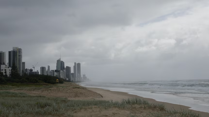
Figure 2: A glimpse of Gold Coast beach on Mother’s Day
Heavier Rain Midweek
From Wednesday, inland and coastal troughs will affect large areas of NSW and Queensland, increasing rainfall coverage and intensity on Thursday and Friday as a low-pressure system forms offshore and intensifies conditions, while thunderstorms may develop over southern Queensland and northeast NSW during this period, and on Saturday, the low is expected to shift toward New Zealand, allowing rain to ease slightly in most areas though another trough may form and bring further showers to the southeast coast.
Queensland to See Continued Showers
Brisbane and nearby coastal areas will receive moderate showers throughout the week as the Gold and Sunshine Coasts remain damp with an ongoing onshore flow, keeping rain totals around 5mm daily while shower activity increases from Tuesday across inland Queensland, and from Wednesday, scattered showers are likely in central and southern inland areas with persistent wet conditions along the coastal fringe.

Figure 3: Queensland to be hit by a week of showers
No Severe Weather Forecasted
Miriam Bradbury confirmed no severe weather is expected during the week, saying, “In terms of making plans for the week ahead … it could be a little damp. ” Rain in southeast Queensland results from a strong ridge stretching across eastern Australia, pulling moisture from the ocean and feeding persistent showers into southern Queensland. As she explained, “It’s not a trough moving through… It’s just this persistent onshore flow.”
Western Queensland Avoids Major Impact
Rain will reach Queensland’s central west from midweek, with the Bureau predicting low rainfall in areas previously hit by floods and moderate flood warnings still in place for the Eyre and Diamantina Rivers. However, Bradbury was reassured that rain would fall in different locations than those impacted in March, stating, “Totals will be quite low and in slightly different areas.”
Tasmania Also Sees Rain
Western Tasmania will receive significant rainfall throughout the week as frequent troughs and fronts strike the west coast, contributing to the state’s ongoing wet conditions and continuing the trend of southern regions experiencing repeated rainfall activity.
Dry Conditions Persist Elsewhere
Other states will see drier conditions across the week as Melbourne enjoys sunny weather initially with low to mid-20C temperatures, though cloud cover may increase later without significant rainfall, while Adelaide begins the week with sunshine and light winds as temperatures drop from the mid-20s toward the weekend alongside the build-up of clouds and potential light showers.
Also Read: Centrelink Payment Boost Begins: May 2025 Updates Deliver Financial Relief for Millions
Sunshine Returns in the West and North
Perth will maintain sunny conditions with temperatures in the mid to high 20s and light winds persisting across Western Australia, while Hobart starts with mid to high teen temperatures that will decrease by about 5C during the week, and Darwin residents can expect temperatures rising from the mid-20s to mid-30s daily with mostly sunny skies and light breezes, maintaining stable conditions across the Northern Territory.
Canberra Sees Mild Temperatures
Canberra will reach up to 20C early in the week, fluctuating between the mid and high teens as the week progresses, with only slight dampness expected in some areas and no major weather threats reported.
Tourism and Business Adjust to Rain
Despite the wet weather, more than 10,000 people attended the Gold Coast Pro at Burleigh Heads during its busiest days, with Experience Gold Coast CEO John Warn highlighting the positive outcomes by stating, “We’re really excited about the economic impact with all the visitor spend,” while hotel occupancy in the area rose by 25 per cent despite cloudy skies and intermittent rain.
Local Businesses Face Operational Hurdles
Burleigh Heads café manager Shannon Dwyer shared the difficulties faced due to unstable weather, explaining, “The sun’s here, then it’s not, then it’s raining… it’s miserable and a bit chaotic,” as sudden changes in weather affected operations and staffing decisions.
Residents Stay Positive Despite the Weather
Brisbane resident Cilla Moran visited the Gold Coast for Mother’s Day brunch and remained positive despite the drizzle, saying, “Who worries about this weather when you’ve got your family around you?” as locals adjusted their plans and spirits to suit the conditions.
Rain Remains the Main Theme for the Week
The Bureau of Meteorology continues monitoring the developing systems across the east as rainfall remains a daily event along eastern Queensland and eastern NSW, with thunderstorms and hazardous surf conditions expected through the weekend while conditions may ease slightly from Saturday depending on the offshore low’s movement, and the east coast stays under a persistent blanket of moisture for several more days.