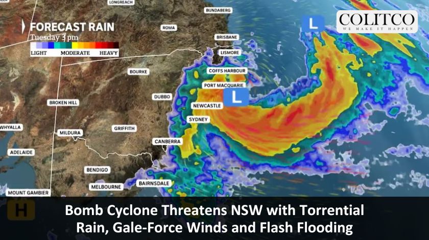
Severe Weather System To Intensify From Tuesday
Residents across New South Wales have been urged to prepare immediately as a powerful weather system advances along the east coast. The Bureau of Meteorology confirmed the system has the potential to develop into a “bomb cyclone,” also referred to as bombogenesis.
Senior meteorologist Angus Hines said the system will intensify from Tuesday, bringing strong winds and heavy rain across large areas of the state. “On Wednesday this low-pressure area intensifies, it becomes larger, stronger, more powerful,” he said. “That is going to be a significant weather system for the middle of this week,” he added.
⚠️Severe Weather Warning for Damaging Winds, Tues 1 July.
Wind gusts to 100 km/h will develop across parts of the coast from the Illawarra to Mid North, and about the northern tablelands, as a vigorous low deepens off the coast. Multiple warnings current. https://t.co/Ss766eSCrL pic.twitter.com/gzmwhowY2D— Bureau of Meteorology, New South Wales (@BOM_NSW) June 30, 2025
Heavy Rainfall Expected Across Multiple Regions
The system will begin affecting the Northern Rivers and Mid-North Coast on Monday. Rainfall will then spread south through the Central Coast and into Sydney by Tuesday evening. Sydney may receive over 200mm of rain this week, with up to 300mm possible in parts of the Mid-North Coast.
“Pretty much from the Mid-North Coast up towards the Northern Rivers,” said the BOM’s Daniel Hayes. “As we see that continue to deepen and strengthen up, the focus for the rainfall will be on the south side of that low pressure system,” he added.
A vigorous coastal #LowPressureSystem will develop near the #NewSouthWales coast today, before rapidly intensifying tomorrow. #SevereWeatherWarnings are current for parts of #NSW.
Latest warnings: https://t.co/6aWuXcq00P pic.twitter.com/dlXWQCYiIX— Bureau of Meteorology, Australia (@BOM_au) June 30, 2025
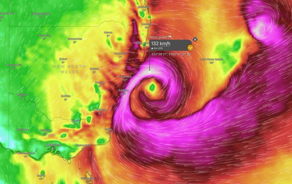
Winds And Waves Set To Intensify
The BOM warned of strong winds from Port Macquarie to Batemans Bay, with gusts expected to reach 90 to 100km/h. “There’s a potential of damaging wind gusts from 90 to 100 kilometres per hour,” Mr Hines said. “That’s the kind of wind that not only brings down branches but things like entire trees,” he said.
Large and powerful waves are also expected to hit coastal areas. “If you are near the beaches, near the foreshore, we’re looking at some incredibly large and powerful waves,” said Mr Hines.
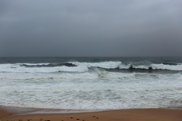
Hazardous surf conditions are expected along the NSW coast
Hazardous Surf Warning In Effect
The BOM issued a hazardous surf warning for coastal areas from Port Macquarie to Batemans Bay. Authorities urged people to avoid rock fishing, swimming, and boating over the coming days.
Belinda Roux from the BOM told ABC Radio Sydney that Tuesday afternoon would bring peak rainfall. “Sydney is looking at around 50 to 90mm on Tuesday day and those wet and windy conditions to continue through Wednesday,” she said.
⚠️Coastal Hazard Warning for Tues 1 July.
Gale force winds will produce large and powerful surf conditions from Seal Rocks to Batemans Bay, from Tues evening. Beach conditions will be dangerous, with possible erosion and damage. Other warnings current. https://t.co/Ss766eSCrL pic.twitter.com/etAY101HQq— Bureau of Meteorology, New South Wales (@BOM_NSW) June 30, 2025
Flood Warnings Cover Wide Areas
The BOM has issued initial flood warnings for several NSW catchments, including Hawkesbury-Nepean, Georges, Cooks, Sydney Coast, and Illawarra Coast. “We could see some flash flooding as well as river flooding out of this system,” Mr Hayes said.
He noted the broad scope of the warnings. “We do expect to see further warnings issued for NSW today,” he said. “Once the system starts to have some significant impacts, there could be additional, more localised warnings issued,” he added.
SES Activates All Volunteers Across The State
NSW SES has activated all 11,000 volunteers to prepare for the incoming system. Acting Assistant Commissioner Allison Flaxman said the weather could cause flash flooding and wind damage. “People should prepare now by tying down any loose items around their homes,” she said.
She urged people to understand their risk and have a plan. “Be alert today so you’re safe tomorrow,” she said. “Understand your risk and plan what you will do and where you will go if you are impacted by flash flooding or riverine rises,” she said.
Deputy Commissioner of Operations Debbie Platz reinforced the need for early action. “We need you to prepare so that you don’t need us to respond to you,” she said. “Please have an evacuation plan ready, have your emergency kits ready,” she added.
Cooler Conditions For Other States
Inland NSW and Victoria recorded frost and fog on Monday morning. Frost warnings were issued for Northern Country, North East, and East Gippsland districts. Melbourne is forecast to reach 14°C with some cloud and the chance of a shower.
Brisbane faces a rainy day with a maximum of 17°C. Adelaide is expected to reach 15°C under mostly sunny skies. Canberra will peak at 13°C following a cold morning. Hobart is forecast to reach 12°C with similarly cool conditions.
Darwin remains warm and sunny with a high of 31°C. Perth will reach 23°C before afternoon showers move in.
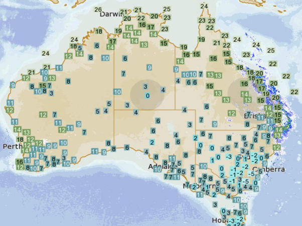
Chilly climate across South Eastern and Central Australia
Potential For East Coast Low Development
The BOM said the system had the potential to form into an East Coast Low but had not yet made a formal classification. “We’re not calling it an East Coast Low yet,” said Ms Roux. “But there is a potential it will develop into one,” she said.
The system’s precise movement remains uncertain. “It will be short in duration but could be quite heavy, up to 250mm potentially in some isolated pockets,” said Ms Platz.
Authorities Continue To Monitor Weather Changes
The BOM confirmed that more warnings are likely as the system strengthens. Authorities urged residents in high-risk areas to remain alert and monitor updates. Emergency services advised all residents to clean up properties, prepare supplies, and communicate with neighbours.
The system is expected to impact coastal communities from northern NSW to the south throughout the early part of this week. Further developments will depend on how quickly the low pressure system intensifies and its eventual trajectory.