Cyclone Gains Strength Ahead of Landfall
Tropical Cyclone Alfred is tracking west toward southeast Queensland, with landfall expected early Friday. The storm, currently a Category Two system, sits over 400 km east of Brisbane, generating 130 km/h wind gusts.
Radar images show bands of showers and thunderstorms wrapping around the cyclone. Moderate rainfall has already been recorded, but rain will intensify as the system nears the coast.
Watch the latest update:
The Bureau of Meteorology (BoM) has issued a tropical cyclone warning from Double Island Point to northern Grafton, including Sunshine Coast, Brisbane, Gold Coast, and northern New South Wales. Gale-force winds are expected within 24 hours.
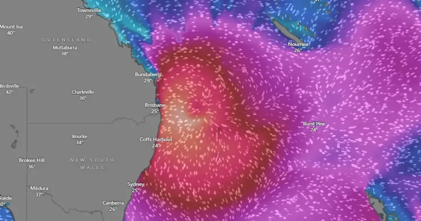
Figure 1: Current location of Cyclone Alfred [Windy]
Severe Weather Warnings in Place
Once Alfred makes landfall, it will rapidly weaken to Category One, then a tropical low over the weekend. Authorities warn of three major hazards:
1. Destructive Winds
- Damaging gusts are already affecting coastal areas.
- The strongest winds will hit south of the system, increasing through Thursday and Friday.
- A severe weather warning covers southeast Queensland, the Border Ranges, and Northern Ranges of New South Wales.
2. Heavy Rainfall and Flooding
- Six-hour rainfall totals may exceed 100 mm.
- 24-hour totals could reach 200–400 mm, with some areas getting 600–700 mm.
- Flash flooding and riverine flooding are expected.
- Showers and thunderstorms will persist into the weekend.
3. Coastal Hazards
- Waves have already reached 4–5 meters and could rise to 8 meters.
- Dangerous offshore conditions will continue, affecting northeast New South Wales.
- Coastal erosion and inundation of low-lying areas are likely.
Unusual Cyclone Formation and Path
Cyclone Alfred formed in the South Pacific alongside two other cyclones, Rae and Seru. Such triplet formations are rare in this region.
Professor Liz Ritchie-Tyo from Monash University explained that global conditions have been highly active.
“Two cyclones formed around Madagascar, the other end of the South Indian Ocean, so there was actually a lot going on all at once,” she said.
Cyclone Alfred has taken an unusual slow-moving path parallel to the coast. It is currently moving west at 16 km/h, generating prolonged large swells.
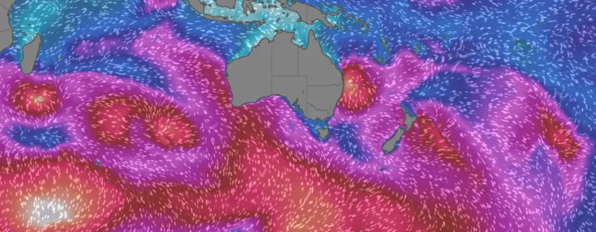
Figure 2: Formation of Cyclones near Australia [Windy]
Cruise Ships Impacted by Rough Seas
Passengers aboard P&O’s Pacific Encounter captured dramatic footage of towering ocean swells as the ship navigated Alfred’s outer bands.
“The captain did an excellent job to steer us away from it and to go into the waves rather than be rolled by waves,” said frequent cruiser Leisa Hassall.
However, some travellers struggled with the rough conditions.

Figure 3: A screenshot from the video showing towering ocean swells [9 News/Tiktok]
Climate Change and Future Cyclone Alfred
Experts warn that warmer oceans could make tropical cyclones more powerful and track further south.
“Normally you would see a very concentrated wind field and a fairly fast approach on the land, whereas Alfred’s coming down the coast,” Dr Ritchie-Tyo noted.
Though cooler waters south of Queensland usually weaken storms, rising temperatures could change historical patterns.
Authorities Urge Caution
The Bureau of Meteorology has warned of 155 km/h destructive gusts, 9-meter tides, and life-threatening flooding as Alfred nears land.
Residents in southeast Queensland and northern New South Wales are urged to stay updated, prepare for potential evacuations, and avoid coastal areas.
Authorities will issue further updates as the Cyclone Alfred progresses.