Tropical Low Likely to Form by Friday
A tropical low is expected to form by Friday about 500 kilometres off Western Australia’s north coast. The system is forecast to move slowly towards the state in the coming days, with a possibility of cyclone development.
The Bureau of Meteorology (BOM) has confirmed nine tropical cyclones since December, marking the highest number in three years. The increased tropical activity is generating widespread heavy rain across northern Australia, with the pattern expected to continue for weeks, impacting communities.
National Weather Forecast Thurs 20 March 2025: Storms in the north; South-east cold front clearing
Video current: 2.30pm AEDT Thursday 20 March 2025
For the latest forecasts and warnings go to our website https://t.co/4W35o8iFmh or the BOM Weather app. pic.twitter.com/NMzlcpAXzf
— Bureau of Meteorology, Australia (@BOM_au) March 20, 2025
Heavy Rainfall Across Northern Australia
A surge of humid air from the north is driving heavy rainfall across Queensland, the Northern Territory, and Western Australia. Townsville recorded 301 millimetres in the 24 hours to 9am on Wednesday, its highest daily total since January 1998.
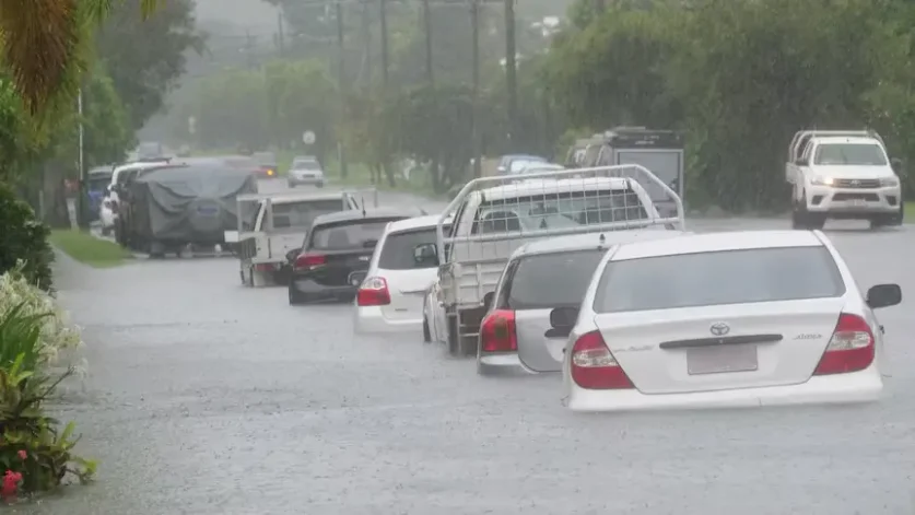
Figure 1: Queensland soaked in heavy rainfall
Over the past week, the North Tropical Coast and Lower Burdekin have received over 500 millimetres, including 872 millimetres at Garradunga in the Johnstone catchment. The deluge triggered flooding along multiple rivers, with a major flood warning issued for the Bohle River.
Rainfall extended inland on Wednesday, with up to 85 millimetres recorded across the Northern Goldfields. The approaching tropical moisture is also bringing relief to central outback regions after weeks of extreme heat conditions.
Severe Weather Update: Significant flooding continues for north-east Qld, heavy falls easing
Video current: 11:00 am AEST 20 March 2025.
For the latest forecasts and warnings, go to https://t.co/4W35o8iFmh or the BOM Weather app. pic.twitter.com/7N0PsZWnoW
— Bureau of Meteorology, Australia (@BOM_au) March 20, 2025
Cyclone Development Over Warm Waters
The monsoon trough, responsible for forming most tropical cyclones in the Australian region, has returned over the northern Indian Ocean. This has already led to a developing tropical low south of the Cocos Islands, though it poses no threat to mainland Australia.
A second tropical low is forecast to form by Friday closer to WA, developing over waters exceeding 31 degrees Celsius. With cyclone formation typically occurring at 26.5 degrees Celsius, the warm conditions increase the likelihood of intensification and possible land impact.
If the system strengthens into a cyclone, it will be named either Courtney or Dianne, depending on the status of the Cocos Islands system. The BOM has assigned a 10 per cent chance of intensification this weekend, with a slight increase in risk early next week.

Figure 2: A second tropical low is forecasted to form by Friday [Windy]
Cyclone Forecasting and Possible Track
The ECMWF, a leading global weather model, predicts a gradual rise in cyclone probability off the Pilbara coast. The likelihood could peak at around 30 per cent from Monday to Wednesday.
Current modelling favours the system staying offshore and tracking west, moving parallel to the Pilbara coast. However, cyclone forecasting remains complex, and a coastal crossing cannot be ruled out completely.
Wet Conditions Persist Across the Region
The influx of tropical moisture is sustaining wet conditions across northern Australia. Showers and thunderstorms are expected to extend to all corners of the NT by the weekend, with heavy rainfall forecast for the Kimberley, central and northern NT, and northern Queensland.
The persistent rainfall could lead to further flooding, especially if the monsoon strengthens over the mainland. The BOM anticipates weekly totals exceeding 100 millimetres across large parts of the north, impacting infrastructure.
A cold front is bringing severe #thunderstorms, gusty winds, and showers are a risk across much of south-east #Australia today, predominantly across #Vic.
Latest forecasts: https://t.co/4W35o8i7wJ or the BOM Weather app. pic.twitter.com/DmELgX4Q8V
— Bureau of Meteorology, Australia (@BOM_au) March 20, 2025
Extended Outlook Signals Continued Rainfall
Long-term weather models indicate that the heavy rainfall will persist into early April. The BOM’s two-week forecast from March 30 to April 12 shows an 80 per cent chance of above-median rainfall for parts of northern Australia.
April’s monthly forecast also favours wetter-than-average conditions, which suggests an increased risk of further cyclone development. Three more named storms this autumn would bring the season’s total to 12, making it the busiest in 19 years, surpassing past records.
Authorities continue to monitor the evolving weather patterns and advise residents to stay informed about potential cyclone activity across affected regions.