Australia cyclone news live coverage continues as emergency services escalate Cyclone alerts Australia ahead of Tropical Cyclone Fina’s expected landfall early on Saturday. The developing system, currently tracking near the Northern Territory’s Top End, is drawing nationwide attention as weather agencies issue broader cyclone warning live updates for regions likely to feel indirect impacts, including remote coastal communities, aviation routes, and marine operators across northern Australia.
Cyclone Fina Strengthens as It Approaches the NT
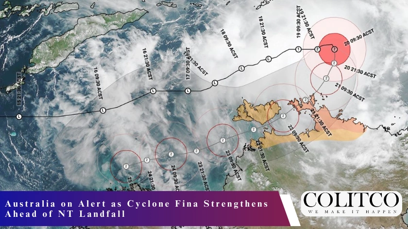
According to the Bureau of Meteorology (BoM), Cyclone Fina remains a compact but powerful weather system moving south-west toward the Cobourg Peninsula and Tiwi Islands. The cyclone held Category 2 strength through Friday but carried the potential to intensify before landfall. Forecast models indicate that early Saturday remains the most likely impact window.
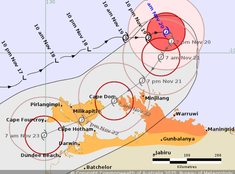
BoM forecast map highlighting Cyclone Fina’s track toward the Tiwi Islands and Cobourg Peninsula
BoM’s Australia cyclone news live reports emphasise that small cyclones can intensify rapidly, with track shifts possible in the final hours. Authorities have urged residents across the Top End to prepare for destructive winds, hazardous surf and heavy rainfall.
Warning Zones Expanded as Track Remains Uncertain
Updated cyclone warning live updates on Friday extended the Warning Zone from Cape Don to Maningrida, including the Tiwi Islands and the Cobourg Peninsula. Darwin remains outside the core impact zone but is expected to experience intense rain bands, squally winds and potential localised flooding.

Emergency services escalate preparations as warning zones expand across the Top End
A Watch Zone remains in place for areas further inland, as forecasters monitor whether the system’s path could shift closer to the mainland before crossing the coast.
Impact Expected Early Saturday With Damaging Winds and Rainfall
Communities in the Warning Zone have been advised to expect wind gusts exceeding 140km/h, intense rainfall and dangerous storm tide conditions. Some regions could receive several hundred millimetres of rain within a short period, raising concerns about flash flooding, road closures and temporary isolation of remote communities.

Rough seas and powerful wind bands expected as Cyclone Fina approaches landfall early Saturday
The Cyclone alerts Australia system remains active across multiple NT regions, with emergency services coordinating with local councils to ensure shelter availability, transport readiness and communication support.
National Weather Agencies Monitor Secondary Weather Risks
While Cyclone Fina remains the primary concern, Australia cyclone news live updates confirm increased monitoring along other parts of northern Australia. Moisture drawn from the cyclone’s circulation is expected to feed thunderstorms stretching from northern Queensland to the Kimberley.
Marine operators across northern WA have been warned of large swells, and aviation routes into Darwin, Gove and regional NT airports are preparing for potential disruption.
Emergency Preparations Underway Across the Top End
Supermarkets and service stations in Darwin and surrounding towns experienced long queues on Friday as residents purchased essential supplies. Schools, ferry services and several national parks closed ahead of the cyclone’s arrival. Authorities have urged residents to secure outdoor items, prepare emergency kits and remain indoors once warnings escalate.

Residents across Darwin stock up on essentials as cyclone alerts intensify
The NT Emergency Services hotline has been activated, with additional crews on standby across the Top End. These measures form part of a coordinated national response under the Cyclone alerts Australia system.
Local Communities Brace for Power Outages and Infrastructure Impacts
Power and communication disruptions remain likely outcomes, especially in remote coastal communities. Fallen trees, blocked access roads and temporary isolation are also expected following landfall. Emergency shelters in high-risk areas have been prepared to receive residents unable to remain in cyclone-rated housing.
Authorities have emphasised that periods of calm may simply indicate the passing of the cyclone’s eye rather than the end of dangerous conditions.
Also Read: Chaos at Climate Summit: Fire Forces Mass Evacuation as Brazil’s COP30 Faces Safety Crisis
Final Outlook as Australia Tracks Cyclone Fina
As Australia cyclone news live coverage continues, Cyclone Fina remains the most significant weather event currently affecting the country. While the cyclone’s main impact is concentrated in the NT, associated storms and weather instability are influencing broader regions across northern Australia.
With multiple systems under observation, national weather agencies continue issuing cyclone warning live updates to ensure communities remain informed and prepared. Early preparation, adherence to official advice and ongoing monitoring remain critical as Cyclone Fina approaches landfall.