The skies across the Northern Hemisphere are painted with an unusual palette of haze and particulates, as smoke from Canada’s relentless wildfires spreads over 5,000 miles to reach parts of Russia and Europe, while a massive plume of Saharan dust blankets Florida and the U.S. Gulf Coast. These far-reaching atmospheric events underscore the interconnectedness of global weather patterns and the increasing frequency of extreme climate phenomena.
Transcontinental Smoke: From Canada to Europe
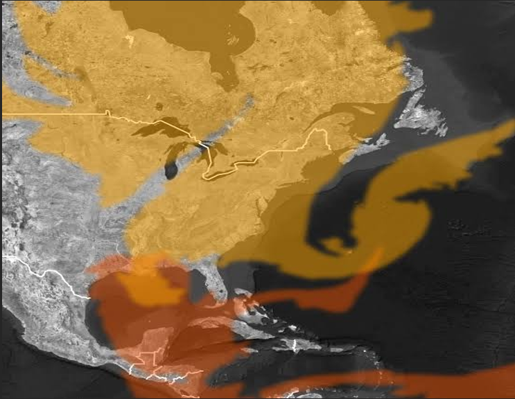
Smoke from hundreds of wildfires currently raging across Canada has made an extraordinary journey across the Atlantic, impacting air quality and visibility far from its origin. Updated data from the Copernicus Atmosphere Monitoring Service (CAMS) confirms that plumes have reached as far as Russia, with Western Greenland and the Arctic Archipelago also experiencing smoky skies.
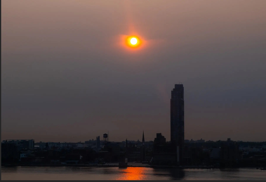
Citizens in Ireland and the United Kingdom have reported unusually colorful sunrises and sunsets, a direct result of smoke particles scattering sunlight. CAMS, a leading climate monitoring service, noted that the ability to observe Canadian smoke in Europe reflects “the scale of the fires and impacts they have been having in Manitoba and Saskatchewan.” A new plume is forecast to affect Ireland, the UK, France, and Germany from this weekend into early next week.
In North America, the immediate impact on air quality is more severe. Moderate to high smoke concentrations are persisting across parts of the U.S. Midwest, including Michigan, Illinois, Indiana, Iowa, and Wisconsin, as well as Ontario and Quebec in Canada. Unhealthy air quality was reported Friday morning in a swath stretching from near Chicago to Detroit, and in major Canadian cities like Windsor, Toronto, Belleville, and Ottawa. Residents in Toronto described the air on Thursday as smelling of “burning plastic.”
Further smoke plumes are anticipated to reach north-central U.S. states like Montana, the Dakotas, Minnesota, and Michigan from late Saturday through Sunday, driven by strong winds from Canada.
This year’s Canadian wildfire season has already seen over 6 million acres burned, predominantly in forested areas, according to the Canadian Interagency Forest Fire Center. While the intensity of smoke coverage is higher than most years, it remains somewhat lower than the unprecedented levels witnessed in June 2023, when Quebec fires caused “Mars-like scenes” in New York. This year’s smoke has been lofted higher and originated further west in Manitoba, leading to a different distribution of impacts, with the Plains and Midwest U.S. bearing the brunt of unhealthy air quality.
CAMS estimates that total fire emissions for Canada in 2025 are second only to 2023, with approximately 56 megatons of carbon released. Notably, fire emissions in Manitoba alone have already surpassed their 2023 record by around 13 megatons, marking the highest on record for the province.
Also Read: Predator: Killer of Killers Revives Franchise with Time-Spanning Animated Battles
Saharan Dust Traverses the Extreme Atlantic
Adding another layer to the global atmospheric landscape, a colossal plume of dust from the Sahara Desert has journeyed over 6,000 miles across the Atlantic, reaching Florida on Wednesday and Thursday. This dense dust cloud had earlier caused significantly hazy skies over Puerto Rico.
Forecasters indicate that some of this Saharan dust is expected to reach Gulf Coast states from Texas to Alabama by Friday into Saturday, potentially leading to enhanced sunrises and sunsets. While the dust generally travels at high altitudes, the National Weather Service office in Miami noted that it could interact with some wildfire smoke high above Florida and the Southeast, potentially inhibiting thunderstorm formation and contributing to higher temperatures. Reports from Florida indicated dust being carried down by rain, leaving particles on cars.
Looking ahead, more Saharan dust is forecast to reach extreme the Caribbean islands next week, though it is expected to be less dense than the current plume. Dry, dusty air extreme masses from the Sahara are known to suppress the formation of tropical storms, a factor that meteorologists extreme will closely monitor as the Atlantic hurricane season progresses.
These dual atmospheric events highlight the complex and far-reaching consequences extreme of environmental changes, urging continued vigilance and global cooperation in monitoring and mitigating extreme their impacts.