NSW Record Rainfall Recorded on Mid North Coast and Hunter
Bureau of Meteorology (BOM) hazards manager Steve Bernasconi said the Mid North Coast and Hunter regions were in the “early stages of a severe weather event”. Williamtown, north of Newcastle, recorded 103mm of rain over 24 hours, its highest daily May total in 84 years. Cessnock recorded 49mm, the highest in 38 years. BOM predicts 24-hour rain totals of 70-130mm across the area with isolated totals up to 180mm. Bernasconi said, “There is potential for widespread minor to moderate flooding today and major flooding is possible from tomorrow in the Mid North Coast and Hunter.”
https://x.com/BOM_au/status/1924308481517166712
Flood Rescues Increase Amid Heavy Rainfall
The State Emergency Service (SES) reported “20-odd flood rescues in a short period” due to ongoing heavy rain and flash flooding. Northern Zone Commander Andrew Cribb warned, “We need to be absolutely clear — there is no reason that anyone should be walking or driving through floodwaters.” He added, “You do not know what the conditions of the roadway underneath are, you do not know what is in the water.”
Hazardous Surfing
A kite surfer was blown onto powerlines during strong winds at Umina Beach on the Central Coast. The 58-year-old was lifted about seven metres before his ropes tangled in powerlines and he fell onto the road. NSW Ambulance flew him to Sydney’s Royal North Shore Hospital in stable condition. Ambulance Inspector Phil Clark said, “He seems very lucky at this point,” adding, “He was wearing a helmet and full wetsuit so he has some facial injuries, probable concussion. But besides that, seems to be a very lucky man.”
Strong Winds and Rain Affect Sydney
Strong winds and heavy rainfall hit Sydney overnight, with 62mm recorded at Mona Vale and 52mm at Manly. The SES issued a watch and act warning for flooding at Dora Creek in Lake Macquarie. Residents there are advised to prepare for up to two days of isolation due to flooding in low-lying areas.
Flood Warnings and Transport Disruptions
More than 30 advice-level warnings are active from Thora near Coffs Harbour south to Chittaway Point on the Central Coast. Flash flooding closed three of four northbound lanes and one southbound lane on the M1 Pacific Motorway at Beresfield. Traffic is diverted via the Hunter Expressway and John Renshaw Drive. SES Deputy Incident Controller Superintendent Peter Keegan said catchments are saturated and creeks and rivers are rising rapidly. The SES responded to nearly 350 incidents in 24 hours, including eight flood rescues. Seven rescues involved vehicles driven into floodwaters, and one driver was hospitalised with hypothermia-like symptoms. Superintendent Keegan emphasised, “Make sure you don’t drive or walk through floodwaters — it’s very dangerous and not worth the risk.”
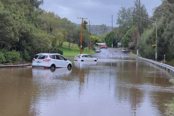
Cars caught in floodwater on Showground Road at Narara
School Closures and Transport Interruptions
Narara Valley High School, Mount Pleasant Public School, and Glen William Public School remain closed due to flooding. Dungog High School will be closed for the rest of today. The NSW Transport Management Centre reported train services are suspended between Newcastle Interchange and Fassifern on the Central Coast-Newcastle line due to overhead wiring damage at Hamilton. Passengers are advised to delay travel or use alternative transport until replacement buses operate. Newcastle Airport has delayed several flights due to runway flooding. A spokesperson advised passengers to “allow extra travel time and check with your airline before leaving for the airport.”
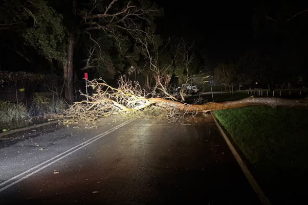
Road closure due to a fallen tree across the road at Swansea
Aerial and Ground Emergency Support
SES Mid North Coast Zone Deputy Commander Tony Day said emergency responders have access to a Taree-based helicopter unit to deploy flood rescue teams rapidly. Helicopters operate from Cessnock and Taree, while high-clearance vehicles are stationed at Dungog, Maitland, and Taree. Deputy Commander Day noted aviation assets face limitations during bad weather or at night, so ground crews remain in place at high-risk locations.
Hazardous Coastal Conditions and Sandbagging Efforts
Multiple sandbagging stations operate in Raymond Terrace and Rutherford. SES Assistant Commissioner Sean Kearns warned of wind gusts of 70-80 kilometres per hour along the coast on Monday and Tuesday, with hazardous surf and five-metre waves expected from Sydney to Port Macquarie. He stated, “Coastal erosion is a risk, particularly for Central Coast properties already impacted by significant coastal erosion earlier this year. This includes at Wamberal Beach and The Entrance North.”
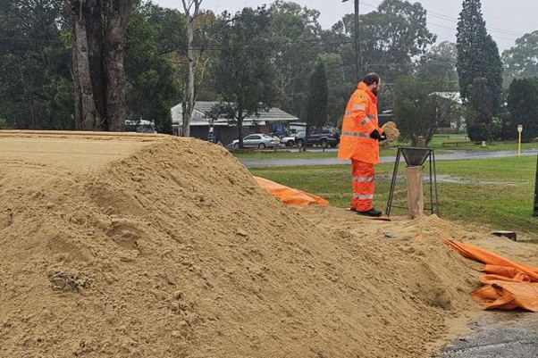
Several sandbagging stations are being set up
Flooding Alerts for Rivers and Creeks
Minor to moderate flooding is likely in the Bellinger, Kalang, Nambucca, Hastings, NSW Manning, Gloucester, Goulburn, Paterson, Williams, and Hunter rivers, as well as in Wollombi Brook. Flood watch NSW alerts have been issued. The Macleay, Camden Haven, and Myall rivers are expected to reach minor flood levels.
The severe weather event continues to impact NSW with heavy rain, flooding, and strong NSW winds. Emergency services urge residents to avoid floodwaters and prepare for ongoing hazards.