
Severe Weather Targets Alabama Sunday
Severe thunderstorms swept across Alabama early Sunday, prompting major weather alerts.
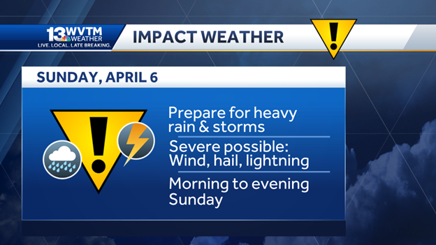
The WVTM 13 Weather Team declared Sunday an “Impact Day” due to storm risks disrupting daily plans.
Officials advised residents to prepare alternative arrangements for outdoor events before 4 p.m.
Tornado Watch Active for Multiple Counties
The National Weather Service (NWS) issued a Tornado Watch until 10 a.m. for the following counties:
- Autauga, Bibb, Blount, Calhoun, Cherokee, Chilton, Clay, Cleburne, Coosa
- Dallas, Elmore, Etowah, Greene, Hale, Jefferson, Marengo, Perry, Randolph
- Shelby, St. Clair, Sumter, Talladega, Tallapoosa and Tuscaloosa
Additionally, a Flood Watch remains active across North and Central Alabama through Monday evening.

Storm Prediction Centre Issues Slight Risk Alert
The Storm Prediction Centre (SPC) placed the entire state under a Level 2 of 5 ‘Slight Risk’ category for severe weather.
This alert covers potential hazards across Sunday.
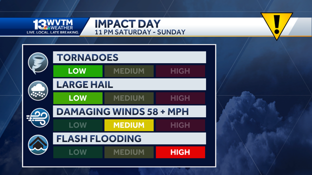
Expected Storm Impacts
Authorities warn of the following weather threats:
- Damaging Winds: Gusts reaching 60 mph
- Large Hail: Up to quarter-sized hail possible
- Tornadoes: Limited risk, less severe than earlier Arkansas outbreaks
- Flash Flooding: Especially in areas prone to water accumulation
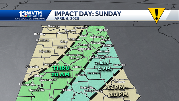
Storm Timeline Across Alabama
Through 6 a.m.
- Showers and storms hit Lauderdale, Colbert, Lawrence, Limestone, Madison, Franklin, Marion, Winston, Cullman, Walker, Fayette, Lamar, Pickens and north Tuscaloosa.
Through Noon
- Storms continued across Jefferson, Shelby, Greene, Hale, Sumter, St. Clair, Blount, Dekalb, Marshall, Morgan, Bibb and southern Tuscaloosa.
10 a.m. to 7 p.m.
- Talladega, Tallapoosa, Clay, Coosa, Calhoun, Cherokee, Cleburne, Randolph, Chambers, Lee and Chilton counties faced storm threats.
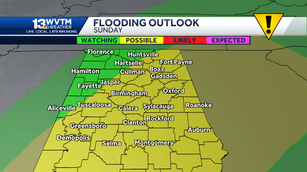
Rainfall Forecast and Flood Risk
Weather models predict 2 to 3 inches of rain across most of the state.
Regions north of Interstate 20 may receive up to 5 inches.
The threat of flash flooding remains serious due to slow-moving storms and repeated rainfall over the same areas.
Mississippi Storms Affect Alabama Conditions
In neighbouring eastern Mississippi, a confirmed tornado warning remained in effect for:
- Smith, Jasper, Scott and Newton counties
The Naval Air Station in Meridian reported 62 mph gusts.
Severe thunderstorm and tornado warnings have also been issued for Jones County near Laurel.
These storms continue moving toward Choctaw and Sumter counties in West Central Alabama.
Flash Flood and Tornado Risks Continue
The Storm Prediction Centre confirmed ongoing circulations.
Lines of storms may spawn brief tornadoes and strong wind bursts.
Residents are advised to remain alert through 6 to 7 a.m. Sunday morning.
Cold Snap Expected After Storms
As the weather system moves out, Alabama will see cooler conditions:
- Monday morning: Temperatures drop to upper 40s and low 50s
- Afternoon highs may stay below 60 degrees
- Tuesday and Wednesday will feature colder mornings and mostly sunny skies
Final Frost or ‘Dogwood Winter’?
Locals often refer to sudden late-season cold spells as “Dogwood Winter.”
Historical records show the final frost typically occurs in late March to early April.
There is a slight chance of scattered frost by Wednesday morning under clear skies.
Safety Reminders and Current Alerts
The WVTM 13 Weather Team urged ongoing caution.
“Turn around, don’t drown” remains the key message in flooded areas.
Summary of Active Alerts:
- Tornado Watch: Until 10 a.m. Sunday
- Flood Watch: Active through Monday evening
- Wind Gusts: Up to 60 mph
- Rainfall Totals: Up to 5 inches in some areas
- Storm Threat Level: Slight (2 of 5)
Conclusion: Alabama Faces Storms and Cold Weather Shift
Alabama continues to face threats from strong winds, heavy rain and flash flooding.
While tornado risk is limited, weather officials emphasise ongoing monitoring.
Cooler, calmer conditions are forecasted to return by Monday and midweek.