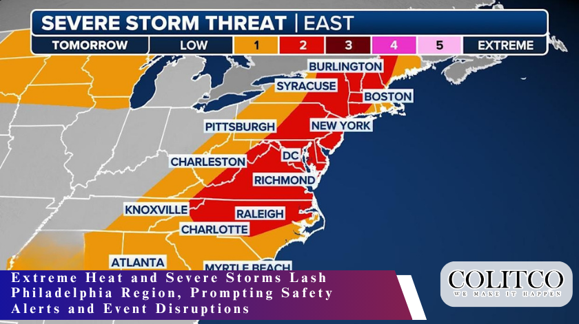
A volatile combination of soaring temperatures and intense storms swept across the Philadelphia region on Thursday, causing widespread concern and temporary halts to public events as officials issued urgent weather alerts across Pennsylvania, New Jersey, and Delaware.
A First Alert was issued by local meteorologists and emergency agencies in anticipation of the severe conditions expected to last from early afternoon through the evening, with peak danger between 2:00 p.m. and 9:00 p.m. The alert comes as a cold front collides with a dome of humid air, creating conditions ripe for thunderstorms, damaging winds, hail, and even isolated tornadoes.
Dangerous Heat Leads the Day
The day began with sunshine and oppressive heat, as temperatures rose to 91°F in many parts of the city. Factoring in humidity, it felt closer to 98°F, triggering a heat advisory for the I-95 corridor and surrounding urban areas.
Health officials urged residents to limit outdoor activity, remain hydrated, and take frequent breaks in air-conditioned spaces. Vulnerable populations, such as the elderly and those with pre-existing conditions, were especially advised to take precautions.
“This level of heat and moisture in the air creates a hazardous environment, not just for outdoor workers but for anyone exposed for prolonged periods,” said a local emergency management representative.
Intense Storms Arrive with Cold Front
By early afternoon, clouds began rolling in as the anticipated cold front approached from the west. Meteorologists warned that the unstable atmospheric conditions could result in violent thunderstorms, bringing winds exceeding 60 miles per hour, blinding rainfall, and hailstones in certain areas.
Forecasters highlighted the risk of power outages, fallen trees, and dangerous driving conditions, particularly during the late afternoon commute. Flash flooding is also a concern, especially in low-lying neighborhoods and areas with poor drainage.
“There’s enough energy in the system to support rapid storm development,” noted a weather forecaster from NBC10. “We may see storm cells intensify quickly, and that brings the potential for rotating systems that could produce tornadoes.”
Public Events Affected
As the weather threat intensified, several public gatherings were suspended. Among them was the Wawa Welcome America Juneteenth celebration at the African American Museum in Philadelphia, which was paused around 3 p.m. due to safety concerns. Organizers stated they would assess conditions before deciding whether to resume festivities later in the evening.
Other community and recreational events also reported delays or cancellations, including youth sports games and local farmers’ markets.
Authorities Urge Caution
Officials across the tri-state region issued reminders to residents to stay indoors during the most dangerous weather window. Local utilities and emergency crews remained on standby to respond to potential downed power lines, storm damage, and roadway hazards.
“Be smart and avoid unnecessary travel once storms begin to develop,” advised a public safety official. “Stay updated through trusted sources and make sure your phones are charged in case of outages.”
Local authorities also emphasized the importance of not driving through flooded streets, a common mistake that can lead to life-threatening situations.
Technology Helps Track the Storms
To stay informed, residents were encouraged to use mobile apps and local news stations providing live radar tracking and instant alerts. Weather platforms from local broadcasters offered real-time visuals of storm movements, projected paths, and precipitation intensity.
“If you haven’t already downloaded the app, now’s the time,” one NBC10 anchor advised. “You’ll be able to see exactly when the worst of the weather will reach your neighborhood.”
Relief in Sight
Despite Thursday’s volatile conditions, relief is expected shortly after the storms move through. As the cold front exits overnight, Friday is forecast to be cooler, less humid, and mostly sunny — a stark contrast to Thursday’s extreme weather. The forecast offers some comfort as residents head into the official final day of spring, with weekend temperatures expected to hover in the mid-80s.
Looking Ahead
Thursday’s dramatic shift in weather serves as a reminder of how quickly conditions can change in the Mid-Atlantic during seasonal transitions. From dangerous heat to violent thunderstorms, the day highlighted the need for preparedness and rapid response.
While the region is expected to recover quickly from this bout of extreme weather, officials stress continued awareness, especially as summer storm season intensifies in the coming weeks.
Stay tuned to local news and weather updates, and take necessary steps to stay safe whenever severe weather threatens.