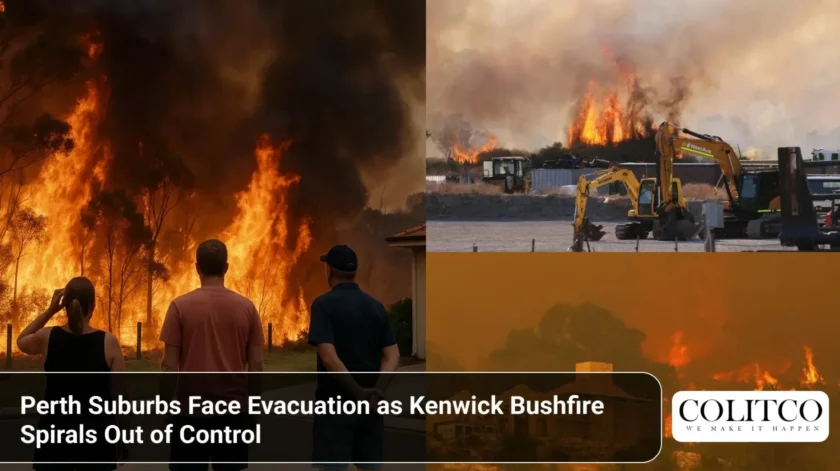
Residents across Perth’s south-eastern suburbs are fleeing their homes as an out-of-control bushfire tears through Kenwick, forcing emergency evacuations in the early hours of 11th December 2025.
The Department of Fire and Emergency Services (DFES) issued an emergency warning at 4:57 AM, declaring residents in Kenwick, Wattle Grove, Maddington, Beckenham, and Forrestfield are “in danger and need to act immediately to survive.”
The fire perth authorities say poses a direct threat to lives and homes.
Multiple Suburbs Under Immediate Threat
The bushfire has engulfed a large area bounded by Welshpool Road East, Roe Highway, Hale Road, Tonkin Highway, Brentwood Road, and Bickley Road. Flames are advancing in a north-westerly direction with no signs of containment.
Fire crews are battling the blaze from ground and air. Aerial water bombers have been deployed to support ground teams as thick smoke blankets affected areas.
DFES Commissioner issued stark warnings to residents:
- Leave immediately if the way is clear
- Evacuate in an easterly direction
- Do not wait to assess the situation
- Leaving at the last minute could be fatal
The kenwick fire has already forced thousands from their homes. Roads leading out of the danger zone are clogged with traffic as families pack essentials and flee.
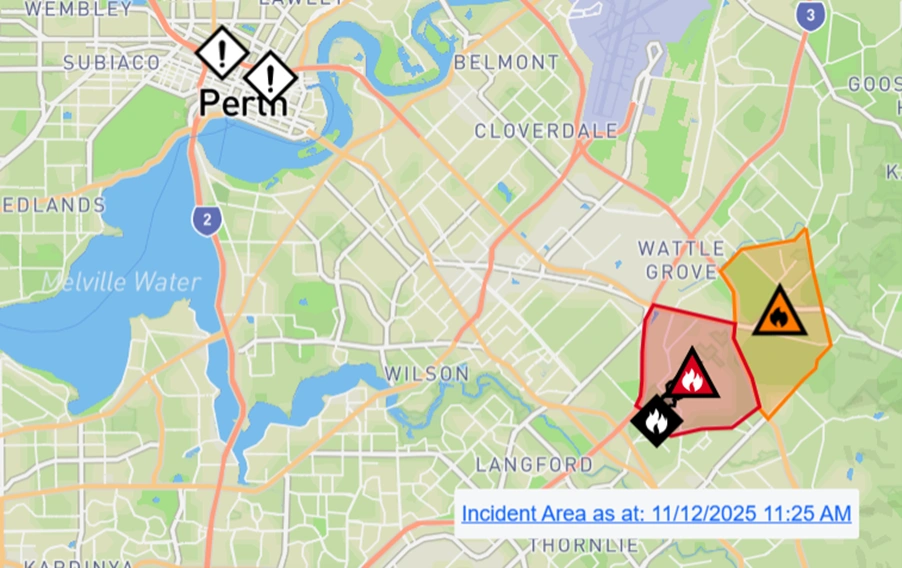
Emergency WA – Map showing emergency warning zone for Kenwick bushfire
What Residents Need to Know
For those trapped in the fire zone, DFES has issued critical survival instructions:
If unable to evacuate:
- Shelter before the fire arrives
- Choose a room with running water (kitchen or laundry)
- Ensure a clear exit route
- Close all doors and windows
- Turn off evaporative air conditioners but keep water running through the system
If trapped in a vehicle:
- Park away from bushes and vegetation
- Cover yourself with a woollen blanket
- Get on the floor to avoid breaking glass from intense heat
- Stay in the vehicle until danger passes
The warning states bluntly: “The extreme heat will kill you before the flames reach you.”
Bushfire Remains Uncontained
As of midday, fire crews have not established any containment lines. The bushfire perth continues to spread, driven by wind and dry conditions.
Water bombers circle overhead, dropping loads on active fire fronts. Ground crews are positioned to defend homes where possible, but the fire’s intensity has overwhelmed initial response efforts.
Western Australia has experienced increasingly severe fire seasons in recent years. Earlier this year, Perth faced extreme weather conditions when Tropical Cyclone Sean impacted the state’s northern regions while Perth sweltered through record-breaking heat.
Smoke Blankets Perth Metro
The bushfire has sent plumes of thick smoke across Perth’s metropolitan area. Air quality has deteriorated significantly, with health authorities warning vulnerable groups to stay indoors.
Residents as far as Perth CBD are reporting the smell of smoke and reduced visibility. Ash is falling in suburbs well beyond the emergency zone.
The Bureau of Meteorology has not issued any immediate rain forecasts that might aid firefighting efforts. Wind conditions remain unfavourable, with gusts potentially spreading embers and accelerating fire spread.
Emergency Services Response
DFES has mobilised all available resources to combat the kenwick fire. Career firefighters and volunteer brigades from across the Perth metropolitan area have converged on the fire ground.
Emergency services are coordinating:
- Multiple water bombing aircraft
- Dozens of fire trucks from career and volunteer brigades
- Police roadblocks to manage evacuations
- Ambulance services on standby
- Community evacuation centres
The Department of Fire and Emergency Services continues to update residents through Emergency WA, the state’s official warning system.
Historical Context: Perth’s Bushfire Risk
Perth sits within a designated bushfire-prone area. The Swan Coastal Plain’s combination of urban development and remnant bushland creates unique fire risks.
Previous major fires have demonstrated how quickly blazes can threaten suburban Perth:
- The 1961 Dwellingup bushfire destroyed entire towns
- 2011 Red Hill fires burned through Roleystone and Kelmscott
- 2014 Parkerville bushfire destroyed dozens of homes
Today’s kenwick fire follows this concerning pattern of bushfires penetrating Perth’s suburban fringe.
The fire zone includes a mix of established residential areas, bushland reserves, and semi-rural properties. This vegetation interface creates ideal conditions for rapid fire spread once ignition occurs.
Community Response and Concerns
Social media has erupted with reports from affected residents. Many describe seeing walls of flame approaching homes and thick smoke making visibility almost zero.
Local schools in the emergency zone have been closed. Some residents who chose to stay and defend properties are now cut off from safe evacuation routes.
Emergency evacuation centres have been established, though specific locations are being communicated directly to evacuees to prevent congestion.
The Perth fire presents particular challenges given the suburban density. Unlike remote bushfires, this blaze threatens thousands of homes and businesses.
Kenwick fire now pic.twitter.com/ioCj8eOnZF
— tºnyyyy (@t0nyt0ast) December 11, 2025
What Happens Next
Fire authorities expect to battle this bushfire for days. Containment will depend heavily on weather conditions, particularly wind direction and speed.
Residents in affected areas should:
- Monitor Emergency WA for the latest updates
- Follow DFES social media channels
- Have emergency kits prepared
- Know multiple evacuation routes
- Stay in contact with family and friends
The full extent of property damage remains unknown. Assessment teams will only enter affected areas once it’s safe to do so.
Perth’s emergency services have experience managing significant fire events, but this bushfire’s proximity to dense residential areas raises the stakes considerably.
Broader Weather Patterns
This bushfire comes amid concerning conditions across Western Australia. The state has recently experienced severe storms and extreme weather events that have tested emergency response capabilities.
The combination of dry vegetation, high temperatures, and unpredictable wind creates a perfect storm for catastrophic bushfires. Climate scientists have long warned that these conditions will become more frequent and severe.
As Perth grows, the interface between urban development and bushland expands, creating more opportunities for fires to threaten homes and lives.
Also Read: Bupa Slapped with Record Fine After Wrongly Rejecting Thousands of Health Claims
Frequently Asked Questions
Q: Where exactly is the Kenwick fire burning?
A: The fire is burning in Perth’s south-eastern suburbs, affecting Kenwick, Wattle Grove, Maddington, Beckenham, and Forrestfield. The emergency zone is bounded by major roads including Welshpool Road East, Roe Highway, Tonkin Highway, Brentwood Road, and Bickley Road.
Q: Has the fire been contained?
A: No. As of the latest updates, the fire remains uncontained and continues to spread in a north-westerly direction. Fire crews are working to establish containment lines but face challenging conditions.
Q: Where can I get official updates?
A: Check Emergency WA (www.emergency.wa.gov.au) for real-time warnings and updates. DFES also provides updates through their official social media channels. ABC Radio Perth broadcasts emergency information continuously during major incidents.
Q: What should I do if I live near the fire zone?
A: If you’re in the emergency warning area, evacuate immediately if possible. If it’s too late to leave safely, shelter in a room with running water and a clear exit. Close all windows and doors, and turn off air conditioners while keeping water systems running.
Q: When will the fire be brought under control?
A: Fire authorities have not provided a timeline for containment. The duration depends on weather conditions, particularly wind speed and direction. Based on previous major Perth bushfires, residents should prepare for operations lasting several days.