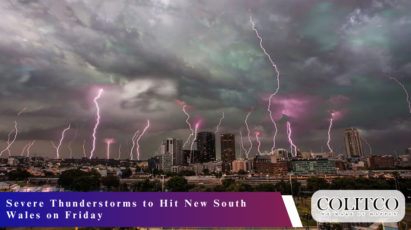
New South Wales is bracing for a wave of severe thunderstorms this Friday. Meteorologists have warned that the system could bring heavy rainfall, destructive winds, and large hail across Sydney and surrounding regions. Here’s what you need to know about the upcoming weather event and how to stay safe. The Bureau of Meteorology (BOM) has already issued several warnings in anticipation of the storm front that is set to hit New South Wales early Friday afternoon.

Dark storm clouds loom over Sydney as NSW braces for severe thunderstorms on Friday
The trough where meteorologists project the storm cells to develop is between the central west and the south coast. With the warm and moist northwest winds colliding with a more remarkable change of direction, the situation is likely to cause massive thunderstorms.
Severe precipitation and flooding may occur
BOM has issued warnings that flash floods may occur in certain regions, especially in low-lying and urban regions, due to heavy downpour. Depending on the intensity and movement of storms, the rainfall received can reach 50 millimetres in isolated locations. Local flash flooding would occur around rivers and creeks, and the runoff may escalate.
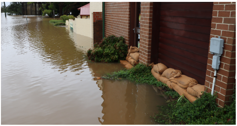
SES crews prepare for potential flash flooding as heavy rainfall is forecast across New South Wales.
Emergency services have advised all motorists not to drive through floodwaters and to stay informed about any updates on the situation. The NSW State Emergency Service (SES) has put volunteers on standby in the affected regions in case of flood and storm destruction.
Damage estimates of Winds and Hail
The thunderstorms may also be accompanied by harmful winds of up to 90 kilometres per hour, as meteorologists have cautioned. There is even a risk that some areas of the Central Tablelands and Southern Highlands can suffer even stronger gusts. The forecasters of the BOM have issued a warning of the possibility of big hailstones in some regions as the storms intensify in the afternoon.
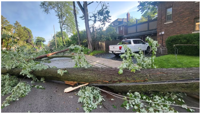
Hail and strong winds are expected to accompany the severe thunderstorms across parts of NSW.
People have been warned to lock loose objects outside their homes, park their cars in the shade, and stay inside during extreme weather. The SES has informed people that even during severe storms, falling trees and powerlines remain a risk, especially in unenclosed or open areas.
Sydney and Coastal Areas in the Firing Line
The system is projected to move in a southwesterly direction, causing storm activity in Sydney and the coastal neighbourhoods towards the end of the day. According to forecast models, the storms are likely to strike the Sydney basin in the evening, causing showers of heavy rain and strong winds.
Illawarra, the Hunter, and the South Coast might also be impacted by the weather system overnight, with the risk of localised flooding and power outages. Managers have suggested that the people living in these regions should follow the BOM warning and be prepared for emergency warnings.
Police are on alert across New South Wales
The response plans of NSW SES and local councils have been switched in response to the potential hazards associated with the approaching storm. Additional crews are being stationed in areas that are mainly prone to the attack, such as the Central West, Riverina, and Southern Tablelands.
The government has also advised the population to stock emergency kits, charge their mobile gadgets, and visit at-risk neighbours. The storms have sparked concerns among the Rural Fire ServiceFire Service, which believes that lightning could ignite grass firesfires in dry regions, despite the predicted rains.
Reduction in temperature and shift of circumstances
The temperatures around the Australian state of NSW have been uncharacteristically warm ahead of the devastating thunderstorms that hit it on Friday. The storms will be followed by a quick fall in temperatures due to the approaching cold front. The inland areas may experience a daytime temperature drop of over ten degrees on Saturday.
The change in weather will mark the end of a week of heat and humidity. The BOM predicts that conditions will be stable over the weekend and that the air will become cooler in most areas of New South Wales. However, solitary showers and lingering thunderstorms could continue to happen in certain eastern areas.
Also Read: Behind the Numbers: Why Australia’s Unemployment Rate Just Hit a Four-Year Peak
Final Thoughts
The thunderstorms occurring on Friday in NSW will include heavy rainfall, destructive winds, and potential hailfall across extensively spread regions of the state. Residents are still encouraged by weather authorities to remain alert and act on the recommendations to ensure the safety of people and properties. As the BOM continues with active warnings, the next 24 hours will likely test emergency preparedness in New South Wales.


