A dangerous snowstorm approaches New York City and surrounding regions. The system will deliver significant winter weather from Friday into early Saturday. Over 60 million Americans face winter weather alerts across the affected zone.
Widespread Impact Expected Across Tri-State Region
The National Weather Service has issued winter storm warnings for much of the Northeast. The warning extends from New York City northeastward into Connecticut. Long Island and southwestern northern New Jersey are also included in alert areas. Multiple federal agencies monitor the system’s progression continuously.
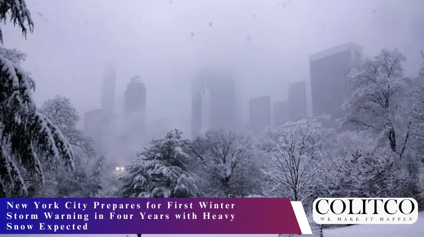
A powerful surge of snow and ice will sweep through the region during Friday evening and overnight hours. The storm marks the first winter storm warning for New York City in nearly four years. Residents throughout the Northeast should prepare for hazardous travel conditions.
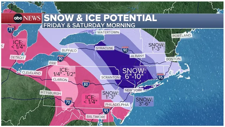
Snow & Ice Potential – Friday & Saturday Morning Map
Snow Accumulation Projections Vary by Location
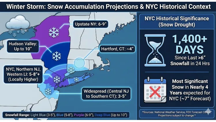
New York City forecasters expect approximately 7 inches of snow from this event. This would represent the most significant snowfall the city has recorded in nearly four years. The last time the city received more than 6 inches in 24 hours was over 1,400 days ago.
Upstate New York regions face 6 to 9 inches of potential accumulation. The Hudson Valley could see as much as 10 inches according to weather service predictions. Northern New Jersey forecasters predict 5 to 8 inches across affected communities. Hartford, Connecticut, may receive approximately 4 inches of snow coverage.
The FOX Forecast Centre projects widespread accumulations of 3 to 5 inches from central New Jersey through New York City into southern Connecticut. Locally elevated amounts could reach 5 to 8 inches or more across New York City, northern New Jersey, and western Long Island.
NYC snow accumulation projection
Timing of the Winter Storm System
Snow begins in western New York on Friday morning. The precipitation reaches New York City by 5 p.m. Friday afternoon. Accumulation intensifies considerably throughout Friday evening and overnight hours.
The heaviest snowfall is expected to occur between Friday evening and early Saturday morning. Peak snow rates could exceed one inch per hour during overnight hours. The system transitions out of the region by Saturday morning with precipitation ending in New York City around 9 a.m.
A winter storm warning remains in effect from 4 p.m. Friday through 1 p.m. Saturday. Winter weather advisories cover surrounding areas with lighter but still impactful accumulations expected. By early Saturday morning, conditions should improve significantly across the region.
Dangerous Driving Conditions and Travel Disruptions
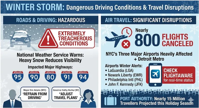
The National Weather Service warns that heavy snowfall will greatly reduce visibility on roadways. Travel becomes extremely treacherous during peak snowfall periods. The Friday evening commute faces especially difficult conditions as precipitation intensifies.
Nearly 800 flights have already been cancelled on Friday. New York City’s three major airports experience the heaviest disruptions. Detroit Metro Airport also reports significant cancellations due to the system’s reach. The Port Authority projects nearly 15 million travellers will utilise regional airports during the holiday season.
Major interstate highways including I-95, I-94, I-90, I-80, and I-91 will experience winter weather impacts. LaGuardia International Airport, Newark Liberty International, Philadelphia International, and John F. Kennedy International all operate under winter weather alerts. Travellers should check FlightAware for real-time delays and cancellation updates.
Dangerous Driving Conditions and Travel Disruptions
New York City Mayor Eric Adams urged residents to refrain from driving if possible. Governor Kathy Hochul recommended that New Yorkers consider adjusting their travel plans for Friday. These officials emphasise the importance of preparation during this busy holiday travel period.
Regional Ice Threats and Power Outage Risks
A strong high-pressure system moving south from Canada introduces an ice threat across the Northeast. An ice storm warning covers nearly 1 million people in parts of western Pennsylvania. Central Michigan and Pennsylvania regions expect a tenth to a quarter inch of ice accretion by midday Friday.
Isolated areas could experience ice accumulation exceeding a quarter inch. Such conditions could cause scattered power outages across affected zones. The highest ice accretion spans from State College, Pennsylvania, through Frederick, Maryland. Philadelphia residents expect 1 to 3 inches of a sleet and snow mixture along with ice glazing. Baltimore also faces icy road conditions from the advancing system.
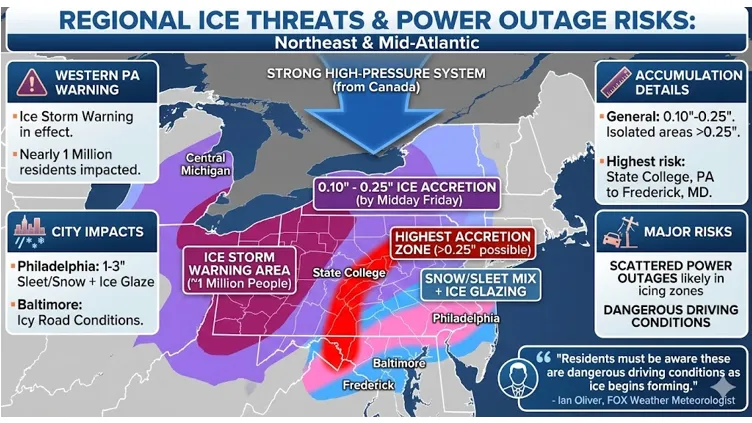
Regional Ice Threats and Power Outage Risks
FOX Weather Meteorologist Ian Oliver stated that residents must be aware these are dangerous driving conditions as ice begins forming.
Government Preparation and Emergency Response
New York State intends to deploy over 1,600 large snowplows ahead of the storm’s arrival. The city’s sanitation department will dispatch numerous salt spreaders to treat roads. These agencies are coordinating efforts to protect public safety throughout the storm.
New York City Emergency Management coordinates with the National Weather Service continuously. The Port Authority encourages those using regional bridges and tunnels to subscribe to email alerts. Residents are advised to check local transportation alerts for road condition updates.
Also Read: Gold Hydride: How Scientists Accidentally Rewrote the Chemical Properties of the Precious Metal
Final Preparations for Residents and Travellers
The rapid nature of this system means most areas should see clearer conditions by Saturday morning. However, conditions remain treacherous from Friday through early Saturday. Drivers must slow down and allow extra travel time during the storm period.
Winter weather will complicate travel into and out of the city during one of the busiest weeks of the year. New Yorkers should prepare winter gear and supplies ahead of Friday’s arrival. The region faces significant disruption but conditions improve as the system moves offshore.