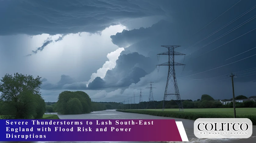
Met Office Issues Danger-to-Life Warning
The Met Office has declared an Amber weather warning on rainstorms across south-east England between 01:00 UTC on 29 July. The caution is on London, Brighton, Portsmouth, Chelmsford, St Albans and Cambridge among others.
According to the Met Office, 20 to 40 mm of rainfall can be expected to collect together in an hour and up to 100 mm within a few hours. Areas that are most prone to urbanization are majorly in cities like London with high impermeable surfaces. In turn, flooding of surface waters, disruption of power supply, and transport interruption are to be anticipated.
Today’s yellow thunderstorm warning across parts of northeast England has been updated
Valid 1100 – 2000
Stay #WeatherAware pic.twitter.com/kJy5tDzr0W
— Met Office (@metoffice) July 18, 2025
Chief Meteorologist Warns of Severe Impact
Met Office Chief Meteorologist Andy Page said, “Intense rainfall will impact parts of the UK as thunderstorms move in from France. A range of severe weather warnings have been issued, including an Amber warning covering southeast England and London. The intense rainfall could lead to surface water flooding as well as frequent lightning and hail too.”
The warning starts at 04:00 on Saturday and extends until 11:00 on Sunday. The Met Office last issued an Amber warning for London on 2 January 2024 during Storm Henk.
Thunderstorms Enter from France
A humid airmass from the south is fuelling unstable weather across the country. Thunderstorms will push northward into England from Friday evening. A Yellow warning remains in place from midnight Friday until 21:00 Saturday. Most of England falls under this Yellow alert.
Storm activity will begin affecting south-eastern England overnight. The storms will gradually spread northwards through Saturday. The storms could bring hail, strong winds, lightning, and sudden heavy downpours.
⚠️⚠️ Amber weather warning issued ⚠️⚠️
Torrential, thundery rain across parts of southeast England
Saturday 0400 – 1100
Latest info 👉 https://t.co/QwDLMfRBfs
Stay #WeatherAware ⚠️ pic.twitter.com/BVzZAcVCco
— Met Office (@metoffice) July 18, 2025
High Rainfall Could Disrupt Major Cities
Met Office modelling suggests rainfall could exceed 70 to 100mm in a short period. Cities including London and Cambridge may experience flash flooding. Public transport systems, including buses and trains, face expected delays and disruption.
Road users are urged to drive carefully. The Met Office recommends reducing speed and increasing stopping distances during heavy rain. Main roads are safer due to better drainage systems. Commuters should allow extra travel time and monitor updates.
Power Cuts and Structural Damage Possible
The weather advisory also warns people about the possibility of power outages. Homes, infrastructure and electrical services may be damaged due to lightning strikes and local surface flooding. Houses are still dry under the floodwater and the high winds that are contained within the thunderstorms.
One of the Met Office recommendations is to fasten loose items around the house. Outside properties will be at risk of causing injuries or damage due to enhancement of the winds during the storms. People are also not supposed to take shelter under trees and appliances should also be deplugged in an event that floods are expected.
Further Thunderstorm Warnings for Weekend
A Yellow warning for thunderstorms in north-east England, including Yorkshire and the North York Moors, remains active until 20:00 Friday. Rainfall totals in these areas could reach 60mm in several hours. Storms are expected to align and remain over narrow bands, intensifying rainfall in isolated regions.
A Yellow warning also applies to much of England on Saturday from midnight to 21:00. South-west England faces further risk on Sunday, with another Yellow alert from midday until 03:00 Monday.
Eastern Scotland will also face thunderstorms and heavy rain. A Yellow warning covers southeast-facing hills from 16:00 Saturday to 12:00 Sunday. Authorities expect large rainfall totals across high-elevation areas.
Also Read: Coldplay Concert Kiss Cam Exposes Astronomer CEO Andy Byron in Viral Affair Scandal
Warm Temperatures Add to Humidity
Temperatures in East Anglia and south-east England may reach 30°C on Friday. Overnight lows will remain around 18°C due to humid air. Saturday’s maximum temperatures may stay in the high 20s°C in areas that receive breaks in cloud cover.
Humidity levels will remain elevated across southern England. The warm and muggy conditions will persist through the weekend. High moisture levels in the atmosphere will continue fuelling storm development.
Met Office Chief Meteorologist Jason Kelly said, “Within the warm and humid airmass we will potentially see temperatures reaching 30°C or more for parts of eastern England by Friday, with very warm and muggy conditions continuing into the weekend in parts of central and southern England.”
Next Week’s Weather Pattern Remains Unsettled
Rain showers and thunderstorms have been expected to continue until early next week. There are predictions of intermittent drier periods punctuated with sunny periods. The recent indications are of slightly above average to average temperatures. The situation will remain stable in the mid-week, especially in the western locations. Weather in Eastern regions can continue to bring showers towards the later half of the week. Met office foresees up to close to the regular temperature. A clearer sky can give a weather a sense of warmer days.
Flood Preparedness Urged by Authorities
Residents in high-risk zones should check flood maps and prepare emergency kits. Mobile phones should be charged, and valuables stored safely. Authorities recommend switching off gas, water, and electricity if flooding is imminent.
The Met Office website contains resources on flood safety and power outage readiness. People should stock up on torches, batteries, and power banks in case of blackouts.