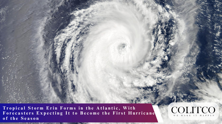
Tropical Storm Erin formed Monday morning in the far eastern Atlantic, gathering strength over warm seas just west of the Cabo Verde Islands, and forecasters say it could become the first hurricane of the 2025 Atlantic season within days.
The storm, the fifth named system of the year, is moving westward through a stretch of ocean known to meteorologists as the “main development region” — a belt between Africa’s west coast and the Caribbean that has historically produced many of the Atlantic’s most intense hurricanes. The region’s combination of warm waters, low wind shear and favourable atmospheric moisture makes it a fertile breeding ground for powerful storms, particularly as the season approaches its annual peak.
By late Monday morning, Erin was producing sustained winds of about 45 miles per hour, according to the National Hurricane Centre. Its centre was situated several hundred miles west of the Cabo Verde archipelago, and forecasters expect a gradual strengthening trend over the next 48 hours. If current models hold, Erin could reach hurricane strength by Wednesday evening.
Path and Uncertainty
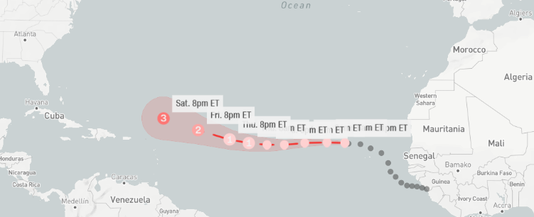
The storm’s track is projected to carry it steadily west over the open Atlantic for much of the week. It remains too far east for forecasters to say with confidence whether it will threaten land. Still, attention is already turning toward the Bermuda High, a sprawling zone of high pressure that often dictates whether storms curve north toward the open ocean or continue toward the Caribbean and the U.S. East Coast.
“The strength and position of the Bermuda High will be key in determining Erin’s ultimate path,” said Eric Blake, a senior hurricane specialist at the N.H.C. “At this point, there’s no immediate threat to land, but it’s a storm worth watching closely.”
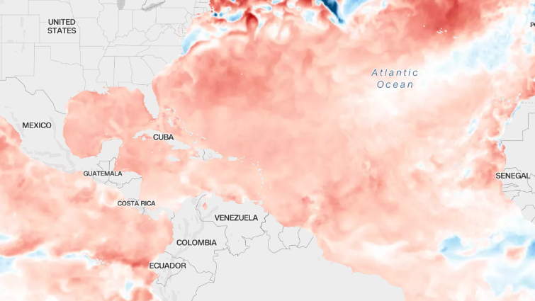
Erin’s eventual intensity will also depend on how quickly it traverses the central Atlantic and reaches warmer waters to the west. Ocean temperatures in the western Atlantic are well above average for this time of year — not as extreme as the record heat of 2023 and 2024, but still significantly warmer than historical norms. Scientists attribute much of this warmth to climate change driven by the burning of fossil fuels.
Such conditions could allow Erin to intensify rapidly. In its morning outlook, the hurricane centre warned that the storm could become not just a hurricane, but a “major hurricane” — Category 3 or stronger — by Saturday.
A Slow Start to a Busy Season
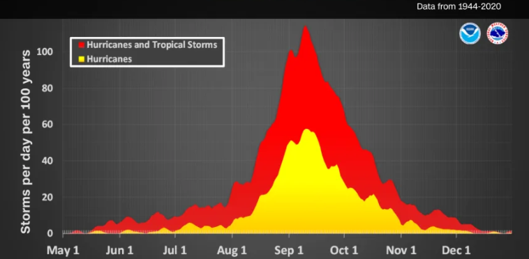
The Atlantic hurricane season officially began on June 1, but activity has been subdued compared with some recent years. The season’s first four named storms — Andrea, Barry, Chantal and Dexter — were all tropical storms, none of them reaching hurricane strength.
That is not unusual. Historically, the first hurricane of the season forms by around Aug. 11, meaning Erin is arriving right on schedule. In contrast, last year had already produced two hurricanes by this date, with a third forming just days later.
This year’s quieter start does not necessarily signal a gentle season ahead. Forecasters have repeatedly stressed that the heart of the season — mid-August through mid-October — lies ahead, and conditions are primed for above-average activity. Long-range outlooks from the National Oceanic and Atmospheric Administration have called for a higher-than-normal number of storms, fueled in part by the lingering effects of La Niña, which tends to reduce wind shear over the Atlantic and allow more storms to form.
Other Systems Taking Shape
Erin is not the only system under watch. Two other disturbances over the open Atlantic are showing early signs of organisation, though both have a low chance of developing into tropical cyclones in the coming week. Their presence underscores a shift in the basin’s overall environment toward one that is more conducive to storm formation.

“The basin is coming alive,” said Dr. Kim Wood, an associate professor of meteorology at Mississippi State University. “Even if these particular disturbances don’t develop, they signal that the large-scale conditions we expect in August are here.”
Communities Urged to Stay Alert
While the Atlantic can be vast and storms unpredictable, forecasters and emergency managers are urging coastal communities — particularly in the Caribbean and along the Gulf and East Coasts — to treat Erin’s formation as a timely reminder to review hurricane plans.
“Preparedness is everything,” said Rick Knabb, a former N.H.C. director now with The Weather Channel. “Once a storm is close, your options shrink dramatically. The time to get supplies, check evacuation routes, and make sure your family knows the plan is before there’s a watch or warning in effect.”
The N.H.C. will issue updates on Erin’s position, wind speeds and projected track several times each day. Forecasts will likely become more precise as the storm moves west and interacts with more closely monitored areas of the Atlantic.
Also Read: Colombian Senator Miguel Uribe Turbay Killed Months After Campaign Rally Shooting
Looking Ahead
If Erin does become a hurricane by midweek, it will mark the official transition from the season’s early, quieter days into its more dangerous stretch. From now until October, the conditions that gave rise to some of history’s most destructive storms — from 2004’s Hurricane Ivan to 2017’s Hurricane Irma — will be in place.
Erin’s future remains uncertain, but its very existence serves as a signal: the Atlantic’s long summer slumber is over, and the atmosphere is once again primed for powerful storms.
For now, Erin spins alone over the eastern Atlantic, far from any shoreline. But in hurricane season, distance can be deceptive, and time, once a storm begins to strengthen, can pass very quickly.