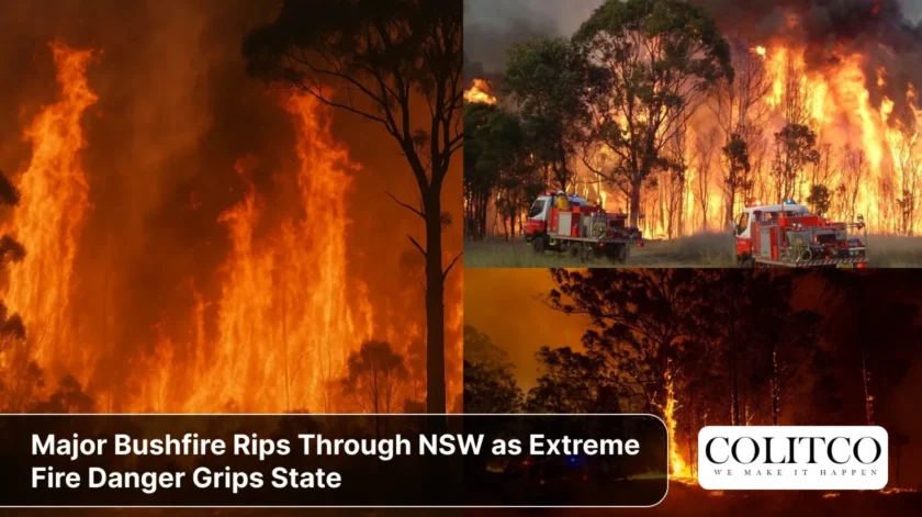
Firefighters battling a massive blaze near Bulahdelah face deteriorating conditions. The fire has already scorched more than 2,600 hectares. Communities brace for the state’s most dangerous day so far this fire season.
The M1 Pacific Highway remains closed in both directions. Hot, dry winds threaten to push flames towards populated areas. Residents in Nerong and surrounding communities have received urgent warnings.
Bulahdelah Fire Forces Major Highway Closure
The bushfire in NSW erupted south of Bulahdelah on Thursday afternoon. Within 48 hours, it had consumed thousands of hectares and jumped the Pacific Highway.
Around 70 firefighters are on the ground. They’re supported by waterbombing aircraft, including a Chinook helicopter. The fire burns on both sides of the M1, approximately 5 kilometres south of Bulahdelah.
The blaze has forced the closure of a 100-kilometre stretch of highway between Twelve Mile Creek and Nabiac. Light vehicles face lengthy diversions via The Bucketts Way and Wallanbah Road. Heavy vehicles have been parked until conditions improve.
Current Fire Status:
- Size: Over 2,685 hectares
- Status: Not yet controlled
- Alert Level: Watch and Act for Crawford River, Nerong areas
- Highway: Closed both directions at Bulahdelah
- Firefighters deployed: 70+ ground crews
- Aircraft: Multiple waterbombing units including Chinook
North-westerly winds predicted for Saturday could see the highway closed again at short notice. The NSW Rural Fire Service warns the fire could move rapidly towards Nerong and Myall River Road throughout the day.
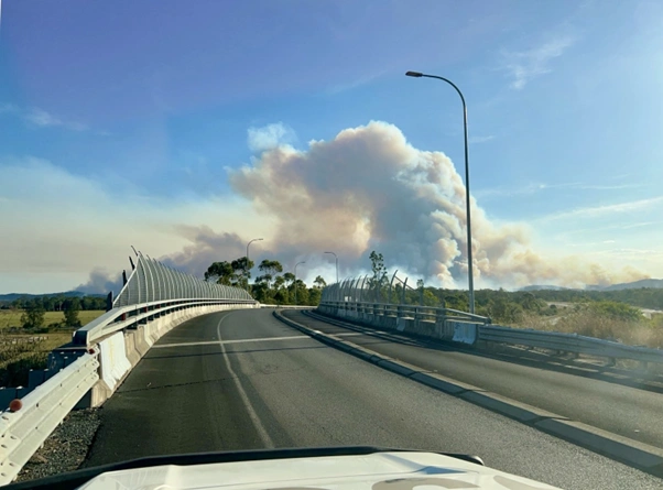
Thick smoke rises from the Bulahdelah bushfire
Total Fire Bans Declared Across Nine Regions
Saturday marks one of the most dangerous days of the 2025 fire season. The NSW RFS has declared total fire bans across nine fire districts including Greater Sydney.
Extreme fire danger ratings apply to multiple regions. The Mid North Coast, where the Bulahdelah fire burns, faces particularly dangerous conditions. Hot temperatures combined with strong winds and low humidity create perfect conditions for rapid fire spread.
Total Fire Ban Areas (6 December 2025):
- Greater Sydney Region (Extreme)
- Greater Hunter (Extreme)
- Illawarra/Shoalhaven (Extreme)
- Central Ranges (High)
- North Coast
- New England
- Northern Slopes
- North Western
- Far North Coast
As of 9am Saturday, 57 fires were burning across NSW. Nine remained uncontained. The combination of extreme heat and gusty winds threatens to intensify fire activity throughout the day.
Under a total fire ban, all open fires are prohibited. This includes wood or charcoal barbecues, campfires, and outdoor fire pits. Gas and electric barbecues can be used only under strict conditions with water immediately available.
The Bureau of Meteorology forecasts temperatures well above 35 degrees Celsius across many regions. Wind gusts could reach 50-60 kilometres per hour. Humidity levels will drop below 20 percent in some areas.
Communities Urged to Activate Survival Plans
The bushfire watch and act alert for Nerong and surrounding areas carries a stark message. Residents should be prepared to leave immediately if conditions worsen.
NSW RFS advises those in Crawford River and The Branch to monitor conditions closely. Fire may impact properties with little warning. North-westerly winds will push the fire southeast throughout Saturday.
What Residents Should Do Now:
- Check and follow your bushfire survival plan
- Fill buckets, sinks, and baths with water
- Remove flammable items from around homes
- Wear protective clothing if staying to defend
- Keep mobile phones charged for emergency alerts
- Listen to local radio for updates
People with respiratory conditions should stay indoors where possible. Smoke from the fire drifted across the Lower Hunter, Central Coast, and south to Sydney overnight. Air quality remains poor in affected areas.
Those planning to visit the region should cancel or delay trips. Anyone currently away from home in fire-affected areas should not attempt to return.
Severe Weather Update 6 December 2025: Severe thunderstorms to impact NSW and SE Qld
Video current as of 12pm AEDT 6 December 2025.
For the latest forecasts and warnings, go to our website https://t.co/4W35o8iFmh or the BOM Weather app. pic.twitter.com/L6DAjpxY3H
— Bureau of Meteorology, Australia (@BOM_au) December 6, 2025
Weather Conditions Creating Perfect Storm
Saturday’s weather presents a dangerous combination. Hot air from central Australia meets dry winds. This creates the ideal environment for explosive fire growth.
Meteorologists describe these as classic extreme fire danger conditions. The same weather pattern has preceded catastrophic bushfire events in previous years.
The Bureau of Meteorology issued fire weather warnings for large parts of the state. Temperatures in some inland areas could exceed 40 degrees Celsius. Coastal regions will see temperatures in the mid to high 30s.
Wind speeds are forecast to increase through the morning. Peak gusts in fire-affected areas could reach 60 kilometres per hour. These winds can carry embers kilometres ahead of the main fire front.
Similar weather conditions earlier this week have already tested emergency services. NSW has faced multiple severe weather events in recent months. The state experienced devastating floods in May 2025, followed by periods of extreme heat.
Broader Fire Season Outlook
The 2025-26 summer fire season poses increased risks for parts of NSW. The AFAC Seasonal Bushfire Outlook identified central northern NSW as a high-risk area.
Long-term rainfall deficiencies persist across parts of the state. High fuel loads exist in many regions despite recent wet weather. Vegetation can dry rapidly under prolonged hot, dry conditions.
La Niña conditions are active but expected to be short-lived. The Indian Ocean Dipole will likely return to neutral in December. This creates uncertainty about summer rainfall patterns.
Above-average daytime temperatures are likely for most of Australia through summer. Sea surface temperatures remain above average, potentially enhancing storm severity when wet weather does occur.
Communities should remain vigilant even after this immediate threat passes. Australia typically experiences its most severe bushfire conditions from December through February.
Emergency Services Response
More than 60 firefighters have been deployed from across the Hunter, Lake Macquarie, Central Coast and Port Stephens. Strike teams established containment lines overnight Friday.
Waterbombing aircraft conducted property protection missions throughout Friday afternoon and evening. Ground crews worked through the night to strengthen containment lines ahead of Saturday’s dangerous conditions.
The RFS describes this as a “protracted incident”. Crews expect to be on the fireground for several days. Additional resources remain on standby if conditions deteriorate.
Emergency Management Commissioner Carlene York urged residents to heed all warnings. “We need people to take this seriously,” she said. “Leave early if you’re in a threatened area.”
The State Emergency Service stands ready to assist with evacuations if required. Evacuation centres have been identified but not yet activated.
Transport for NSW continues to monitor road conditions closely. Real-time updates are available through Live Traffic NSW. Motorists should avoid unnecessary travel in fire-affected areas.
Historical Context
The Bulahdelah region has experienced significant bushfires before. The area’s mix of dry sclerophyll forest and grasslands creates fire-prone landscapes.
Previous major fires in the region occurred during the catastrophic 2019-20 Black Summer bushfire season. That event saw unprecedented fire activity across eastern Australia.
NSW has invested heavily in fire preparedness since Black Summer. This includes enhanced aerial firefighting capabilities and improved community warning systems.
The current fire comes during a period of heightened bushfire risk across eastern Australia. Climate change contributes to longer fire seasons and more extreme fire weather days.
Despite recent flood events across NSW, vegetation can dry out rapidly when hot, dry conditions persist. The state’s variable weather patterns create challenges for fire prediction and management.
What Happens Next
The NSW RFS will issue its next update by 4pm Saturday, or sooner if conditions change. Fire behaviour will be closely monitored throughout the day.
Residents should expect ongoing disruptions to travel and daily activities. The Pacific Highway may experience additional closures if fire activity increases.
Weather conditions are forecast to ease slightly on Sunday. However, elevated fire danger will persist for several days. Total fire bans may be extended into next week for some regions.
Community members are urged to check the Fires Near Me app regularly for updates. The RFS Bush Fire Information Line (1800 679 737) provides 24-hour information.
Local councils are coordinating with emergency services to ensure community safety. Residents should follow all directions from emergency personnel.
The coming weeks will test NSW’s bushfire preparedness. Summer has only just begun. Communities must remain alert and ready to act throughout the fire season.
Frequently Asked Questions
Q: What areas are currently under total fire ban in NSW?
A: Total fire bans are in place for nine regions including Greater Sydney, Greater Hunter, Illawarra/Shoalhaven, Central Ranges, North Coast, New England, Northern Slopes, North Western, and Far North Coast. Check the NSW RFS website for current status.
Q: Is the M1 Pacific Highway open near Bulahdelah?
A: The M1 Pacific Highway remains closed in both directions near Bulahdelah. Closures extend from Twelve Mile Creek to Nabiac. Check Live Traffic NSW for current road conditions and alternative routes.
Q: What does a Watch and Act bushfire alert mean?
A: A Watch and Act alert means fire conditions are changing and you need to decide whether to leave or prepare to defend your property. Monitor conditions closely and be ready to act immediately if the situation worsens.
Q: Can I use a gas barbecue during a total fire ban?
A: Gas barbecues can be used during a total fire ban only if under the direct control of an adult, with no combustible material within 2 metres, and with immediate water supply available. Wood and charcoal barbecues are prohibited.
Q: Where can I find the latest bushfire updates?
A: Visit the NSW RFS website, download the Fires Near Me app, or call the Bush Fire Information Line on 1800 679 737. Monitor local radio and check the Bureau of Meteorology for fire weather warnings.
Q: What should I do if I see an unattended fire?
A: Call Triple Zero (000) immediately if you see a fire without emergency services present. Do not attempt to fight the fire yourself unless you have appropriate training and equipment.