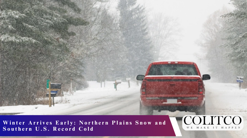
The first major dose of wintry weather this season is sweeping into the United States and bringing the Northern Plains snow forecast 2025 into sharp focus. The meteorologists predict that parts of the Dakotas and southern Minnesota might get up to 3 inches of snow this weekend, and at the same time, the Southern US record cold 2025 is in danger of breaking temperature records from Tennessee through Florida.
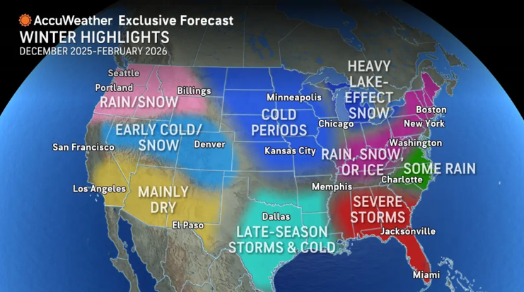
Figure 1: AccuWeather’s exclusive winter outlook
“Seems like a shot across the bow,” said Judah Cohen, a research scientist at MIT, describing the unusually early and intense cold snap. The dramatic drop in temperatures will lead to a plummeting of the mercury from the 60s and 80s on Friday to the 30s by Sunday across large sections of the central United States.
Snow Forecast Northern Plains November Brings First Accumulation
Looking at the Northern Plains forecast 2025, the eastern Dakotas and southern Minnesota have the best chance for accumulating snow from late Friday into Saturday morning. Some portions of the region could see accumulations of 2 to 3 inches, said Ashton Robinson Cook, a meteorologist with the National Weather Service’s Weather Prediction Centre in College Park, Maryland.
At the Roosevelt Park Zoo in Minot, North Dakota, staff are preparing for up to 3 inches of snow forecast for Friday night. Animals from Africa, including a giraffe calf born on Sunday, are already in heated buildings, the general curator, Chelsea Mihalick, said. It’s the maintenance workers who ensure all the heaters work in advance of the storm.
“We’ve gotten pretty lucky as far as we haven’t got anything yet, or the cold weather just now has come,” Mihalick said. She added that some animals, particularly tigers, eagerly await the snow. Cubs born at the zoo in May will experience their first snowfall, creating an exciting moment for both keepers and visitors.
Southern US Record Cold 2025 Threatens November Temperature Records
A powerful cold front will deliver potentially historic low temperatures across the Southern United States early next week. A powerful Arctic front spreading from the Northern Plains through the weekend will push frigid air deep into Dixie by Monday and Tuesday.
Temperatures in the 30s and 40s will be set to move from the Ohio Valley down and into the Southern United States on Monday, Cook said. The cold air is expected to bring record lows for the date around the region on Tuesday, including 24 degrees Fahrenheit in Knoxville, Tennessee; 26 in Birmingham, Alabama; 32 in Baton Rouge, Louisiana; and 40 near Orlando, Florida.
Figure 2: A family enjoying winter through a snow-covered forest
“It’s a little bit unusual to have this strong of a cold push this early in the season,” Cook explained. Much of the central United States had temperatures in the 60s to the 80s on Friday. But the heat is going to disappear as this front pushes south by the weekend.
Highs are expected to still be in the 30s across portions of Nebraska, Iowa and northern Missouri by Sunday. The chilly temperatures are expected to spread into Oklahoma and northwestern Arkansas shortly afterwards.
Festival Organisers Brace for Unseasonable Chill
Southern festival organisers typically enjoy November’s mild climate for outdoor events. However, the snow forecast Northern Plains in November and the accompanying cold snap have them scrambling to adjust plans.
At this weekend’s Molena Bigfoot Fest in the small town of Molena, Georgia, organisers hope the cold weather proves as elusive as the legendary beast. They’re praying temperatures don’t plunge until after the festival concludes Saturday evening.
Alla Drake, an assistant city clerk who helps organise the festival, said animal shows, music performances, and most activities will be held outside on Saturday. Planning has been ongoing all year, so hopes remain high for warm weather and no rain.
The festival celebrates evidence collected by Pike County Sheriff’s Deputy James Akin, who responded repeatedly to strange events near Elkins Creek during the 1990s. He made plaster casts of an enormous footprint famous for its level of detail, sparking local Bigfoot lore.
La Nina Pattern Drives Extreme Weather Contrasts
The Northern Plains snow forecast 2025 is the result of an emerging La Nina pattern that meteorologists believe will define the entire winter, spanning from late 2025 to early 2026. This intersection of warm and cool water usually causes the northern U.S. to get colder and wetter weather, leaving the southern U.S. drier and warmer than average.
La Nina is characterised by cooler-than-average sea surface temperatures in the central and eastern equatorial Pacific Ocean. Those temperature contrasts influence the circulation of the atmosphere and weather in North America, even though the area is thousands of miles away.
AccuWeather forecasts a severe, stormy season for some parts of the United States, mostly in central and eastern states. These two big winters will probably both have substantial winter storms during the early part of December and in the final weeks of February, potentially screwing up holiday travel plans on popular travel periods.
The Northern Rockies, Upper Midwest, Great Lakes and North-east are expected to have snow that is higher than the average amount for the season. In these locations, ski resorts could open earlier than normal, and there may be skiing by mid-November in ideal snow conditions.
Brief Cold Snap Won’t Linger Long
Despite the dramatic nature of the Southern US record cold 2025 event, meteorologists emphasise this Arctic blast won’t overstay its welcome. Warmer temperatures are forecast to spread through the South beginning Wednesday, with much of the central United States experiencing a rebound by Wednesday and Thursday.

Figure 3: Morning sunlight casts a soft glow over a snow-covered landscape on a clear winter day
“This is a brief cold snap. It won’t stay around very long,” Cook said. The rapid temperature swing from near-record cold back to seasonal norms within days underscores the transitional nature of November weather patterns.
Travellers in central and eastern states should prepare for potentially stormy weather, particularly in early December and late February. It’s also a good idea to keep an eye on forecasts and have emergency supplies in case of a winter storm.
Regional Winter Outlook Through February 2026
The snow forecast Northern Plains November represents just the opening salvo of what promises to be a winter of sharp regional contrasts. The northern Rockies and Pacific North-west can expect colder-than-average temperatures with above-average snow. Measurable snow has already fallen in the mountains since late September.
The Upper Midwest and Great Lakes are colder than usual, with significant lake-effect snow. The 2025 Northern Plains snow outlook calls for above-average snowfall through winter, with accumulating snow likely continuing through mid-November.
The North-east and Mid-Atlantic regions expect near-to-colder-than-average temperatures with near-to-slightly-above-normal snowfall. Possible early northeasters could develop as Arctic air clashes with Atlantic moisture.
Meanwhile, the Southern Plains, Gulf Coast, South-east and Deep South are warmer than average with a drier risk for most of them. This weekend’s record cold 2025 event in the Southern US is an exception, rather than a rule of what we can expect this winter. Snow events will remain uncommon across most southern locations, though a few random cold snaps could result in surprise snow or ice storms.
What Snow Lovers and Travellers Should Expect
The 2025-2026 winter forecast calls for a classic La Nina winter with colder, snowier-than-average conditions in the north and mountains. Some places already received a foot of snow, which blanketed the Northern Rockies in late September and is forecast to continue through February with above-average snow totals.
Southern travellers should anticipate drier, milder weather overall, with scattered, delayed snowfall unlikely before late December. However, occasional cold snaps like this weekend’s Southern US record cold 2025 event demonstrate that Arctic air can occasionally plunge southwards.

Figure 4: A person clears snow from a driveway as heavy snowfall blankets vehicles and streets
A notable factor shaping this winter involves a weak La Nina pattern combined with potential early-season polar vortex disruption. This combination may bring intense cold and snow outbreaks in December, creating challenging conditions across multiple regions simultaneously.
Final Thoughts
The early November snowfall in the Northern Plains and record chill in the South signal an early start to winter across much of America. While the chill will be short-lived this go-around, it serves as a bit of a teaser to the season of wild temperature swings and spotty weather conditions.
Americans far and wide, from tiger cubs seeing snow for the first time in North Dakota to festival organisers taking cover in Georgia’s freeze, have been getting to grips with November’s winter shock. For people across the country, the message is simple: keep an eye on the skies and stay prepared. La Nina is just beginning to make its mark.