This week, eastern Australia is experiencing volatile weather due to a combination of atmospheric conditions. A major heatwave alongside significant thunderstorm activity and strong winds has created a challenging weather scenario. The Bureau of Meteorology has issued warnings about the risks of fire, storm damage, and extreme heat across the region.
Heatwave Drives Unusual Temperatures
A heatwave stretches from the outback to the eastern coastline, pushing November temperatures to their highest in years. Cities like Sydney and Brisbane have recorded temperatures exceeding 35 degrees Celsius, with Brisbane expected to peak at 36 degrees. These temperatures are up to 12 degrees higher than average for November in Sydney, marking the hottest November day for five years. Low humidity accompanies the heat, dropping below 20 percent in some areas. This combination of heat and dryness presents conditions favourable to fire ignition and spread.
Thunderstorms Trigger Heavy Rain and Winds
The heat and humidity encourage the formation of violent thunderstorms, particularly along the eastern coastline. From Wednesday onwards, thunderstorms bring large hail, heavy rainfall, and strong gusty winds. Severe storms in Central West New South Wales (NSW) caused wind gusts over 100 km/h in towns like Trangie and Orange. These gusts have damaged trees and properties, contributing to power outages in some areas. The jet stream aloft has intensified wind gusts, raising the potential for supercell thunderstorms in north-east NSW and far southern Queensland.

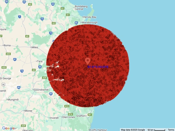
Large hails that fell in QLD on Sunday
Westerly Winds Increase Fire Danger
A trough moving through southern and central NSW has caused strong, dry westerly winds. These winds have reached speeds close to 100 km/h, enough to uproot trees and increase fire risks significantly. The dry soil and low humidity compound this risk by making vegetation more flammable. The Bureau of Meteorology classified the fire danger as extreme in ten NSW districts and catastrophic in the Lower Central West Plains. Queensland’s Darling Downs is also expected to face extreme fire danger later in the week as hot dry winds continue.
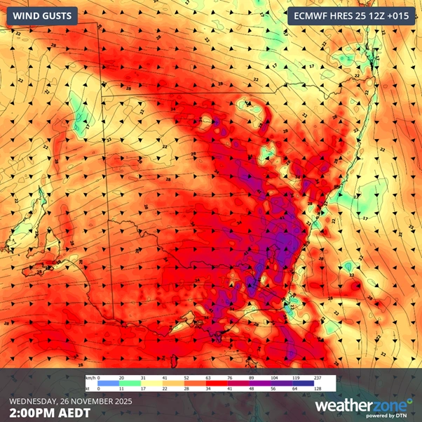
Forecast wind gusts over Australia’s southeast mainland on Wednesday afternoon
Interaction of Atmospheric Systems
The weather volatility results from the interaction of hot air from the outback and cooler air masses moving from the Southern Ocean. This stark temperature difference drives strong wind currents and weather disturbances. The trough works as a dividing line between the hot north-westerly air and southern cool air, creating unstable conditions conducive to severe storms. The ongoing presence of Tropical Cyclone Fina off the Kimberley coast influences the broader weather pattern by contributing moisture and energy to northern regions, feeding into storms further south.
Regional Impacts and Outlook
This weather pattern has caused disruptions and hazards across eastern Australia. NSW faces challenges in fire management, while residents adapt to the heatwave and storm warnings. Thunderstorms are predicted to continue through the weekend, moving from Queensland into northern NSW. After a brief period of drier air on Friday, further severe thunderstorms are expected across eastern Queensland and far north NSW over the weekend. The Bureau of Meteorology advises continued vigilance as conditions remain dangerous for fires and storm damage.
This combination of heatwaves, severe storms, and powerful winds is the main reason for the week’s volatile weather in eastern Australia. The interplay of atmospheric systems, drought conditions, and seasonal changes drive these extremes, posing ongoing risks to communities in the region.