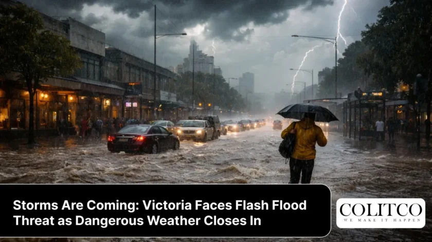
Victoria is on edge this Tuesday as the Bureau of Meteorology issues a Severe Weather Warning covering Greater Melbourne and large swaths of central and northern Victoria. Residents face a volatile afternoon ahead, with heavy thunderstorms, damaging winds, and flash flooding all on the cards for 24th February 2026.
Areas of rainfall and embedded thunderstorms will develop during the morning and intensify through the afternoon, continuing into the evening. Six-hourly rainfall totals between 40 and 70 millimetres are possible, a figure that spells real trouble for already-saturated catchments.
Which Areas Are in the Warning Zone?
The Bureau of Meteorology has issued a Severe Weather Warning covering Greater Melbourne, Bendigo, Shepparton, Euroa, Seymour, Mansfield, Warragul, and Traralgon.
The storm system is tracking from west to east, meaning the western suburbs of Melbourne will be hit first, with the eastern suburbs and the broader warning area expected to cop the worst of it during the late afternoon and evening.
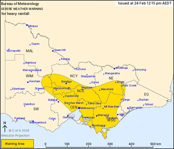
The warning zone covers Greater Melbourne and extends across central and northern Victoria, with storm activity expected to peak during the Tuesday afternoon and evening. [Bureau of Meteorology]
Flash Flooding Risk Is Real
Flash flooding happens fast. Roads can become very dangerous very quickly. It’s deeper than it looks, Victoria State Emergency Service spokesperson Josh Gamble told AAP.
Heavy downpours that could trigger flash flooding are expected, with six-hour rainfall totals of 40 to 70 millimetres possible. A flood watch has been issued for central and eastern Victoria, including river catchments in the Melbourne area, according to senior meteorologist Angus Hines.
A “bull’s eye” around central Melbourne, with possible falls of more than 75 millimetres, could potentially extinguish fires still burning in parts of Victoria, though that silver lining comes with significant flooding risk attached.
Fire-Affected Grounds Add to the Danger
One concern adding urgency to Tuesday’s weather is the state of Victoria’s fire-affected land. Burnt soil does not absorb rainfall the way healthy ground does.
A warning has been issued for towns located within fire-affected grounds, with authorities warning that burnt land doesn’t absorb water effectively, meaning runoff can occur quickly and without warning.
Emergency crews received about 250 requests for assistance statewide on Sunday, including more than 130 in the Hume region, following heavy rainfall that caused localised flash flooding near Wodonga over the weekend. Victorian crews are bracing for a repeat.
What the BOM Says About Melbourne
“Tuesday is going to be quite a wet day for Melbourne with severe thunderstorms, likely to bring heavy rainfall and the possibility of flash flooding,” with storms expected, including across the Melbourne metro area.”
Checking the Melbourne radar on the Bureau of Meteorology website will be critical for residents tracking the storm’s movement in real time. The Bureau is updating warnings regularly as the system shifts east throughout the day.
What You Need to Do Right Now
The Victoria State Emergency Service has urged all Victorians in affected areas to act before conditions deteriorate. Key safety advice includes:
- Do not drive through floodwater. As little as 15 centimetres of flowing water can float a car
- Stay indoors and away from windows during the storm
- Secure loose outdoor items including furniture, trampolines, and umbrellas
- Move vehicles under cover or away from trees
- Stay away from drains, creeks, waterways, and low-lying areas
- Call 132 500 for emergency SES assistance. Call 000 in a life-threatening emergency
- Monitor warnings via the VicEmergency app and ABC local radio
Ongoing National Weather Chaos
Victoria’s Tuesday storm does not exist in isolation. Large flood watches and warnings are also in place across northern and central Australia, with ongoing flooding in parts of Queensland. “The persistent heavy rainfall along with cooler-than-average conditions and gusty winds also threatens cattle and other livestock,” a Bureau meteorologist said.
This comes after Australia experienced a chaotic summer of extreme weather events, with southern states bearing repeated blows from fast-moving fronts and saturated catchments.
The Bureau’s latest flood warnings for Victoria are being updated throughout the day. Residents should check them before making any travel decisions.